5-day weather forecast Rio de Janeiro Sep 18, 2026

21°18° · Patchy rain possible

Weather forecast Rio de Janeiro Friday Sep 18, 2026: patchy rain possible, temperature from 18 °C to 21 °C.

Precipitation probability 52%. Wind up to 6.39 m/s (gusts 7.81 m/s). Air humidity 78–91%, atmospheric pressure 767–770 mm Hg, UV index up to 6.2.

Sunrise 05:46
Sunset 17:47
First Quarter53% illuminated
Moonrise 10:58 · Moonset 00:18
Chart
Table

Forecast from 18 °C to 21 °C and precipitation

Temperature & Precipitation
Time00:0001:0002:0003:0004:0005:0006:0007:0008:0009:0010:0011:0012:0013:0014:0015:0016:0017:0018:0019:0020:0021:0022:0023:00
Temperature (°C)181818181818181819192020202121212020202020191919
Precipitation (mm/hr)0.340.110.140.090.080.050.050.050.050.040.040.030.010.010000000000

Cloud cover and precipitation probability

Cloud cover & Rain chance
Time00:0001:0002:0003:0004:0005:0006:0007:0008:0009:0010:0011:0012:0013:0014:0015:0016:0017:0018:0019:0020:0021:0022:0023:00
Cloud cover (%)93100100100100100981001009994887065726155819475808782100
Rain chance (%)524143403835353534323026201717151520232021232226

Wind speed and direction

Wind & Wind gust
Time00:0001:0002:0003:0004:0005:0006:0007:0008:0009:0010:0011:0012:0013:0014:0015:0016:0017:0018:0019:0020:0021:0022:0023:00
Wind (m/s)4.394.394.313.893.613.813.8144.394.695.316.196.396.116.1165.896.116.116.115.395.55.615.5
Wind gust (m/s)7.116.4265.725.615.835.815.836.316.56.617.427.817.116.926.646.947.317.397.617.117.397.537.72
Wind direction (°)ENE 73°ENE 74°ENE 67°ENE 62°ENE 62°ENE 61°ENE 61°ENE 67°ENE 64°ENE 67°ENE 78°E 79°E 81°E 83°E 86°E 86°E 88°E 86°E 79°ENE 73°ENE 76°ENE 74°ENE 70°ENE 64°

Air humidity

Humidity
Time00:0001:0002:0003:0004:0005:0006:0007:0008:0009:0010:0011:0012:0013:0014:0015:0016:0017:0018:0019:0020:0021:0022:0023:00
Humidity (%)919191919191919089888684837978798081828383848484

Atmospheric pressure

Pressure
Time00:0001:0002:0003:0004:0005:0006:0007:0008:0009:0010:0011:0012:0013:0014:0015:0016:0017:0018:0019:0020:0021:0022:0023:00
Pressure (mm Hg)770770769769768769770770770770770770769768767767767767767767768768768768

Ultraviolet index

UV Index
Time00:0001:0002:0003:0004:0005:0006:0007:0008:0009:0010:0011:0012:0013:0014:0015:0016:0017:0018:0019:0020:0021:0022:0023:00
UV Index00000000.21245.85.96.24.42.310.3000000

Air quality & pollen

Air quality
Time00:0001:0002:0003:0004:0005:0006:0007:0008:0009:0010:0011:0012:0013:0014:0015:0016:0017:0018:0019:0020:0021:0022:0023:00
PM2.5 (µg/m³)1817.315.714.613.913.515.415.51412.61212.213.615.51718.517.917.517.317.316.916.515.815
PM10 (µg/m³)2221.319.317.816.715.917.317.616.415.415.115.81820.823.325.72524.523.723.723.323.422.821.6
Ozone (O₃) (µg/m³)25242423212022314355667685931001008972584943393737
NO₂ (µg/m³)32.130.729.127.525.924.322.620.81916.713.59.97.25.75.269.213.817.218.418.417.816.614.8
SO₂ (µg/m³)6.56.36.15.95.65.45.66.78.39.18.57.26.15.44.94.64.54.54.54.64.64.64.33.9
CO (µg/m³)12911910699103113125138152162166166162149132123132148157147129133.8139138.5

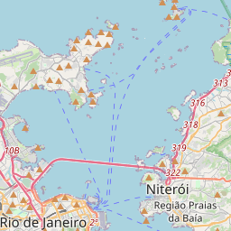
Rio de Janeiro on the map

Data Sources & Methodology

Our weather forecasts are powered by a professional weather data provider that aggregates data from national weather services, satellite observations, radar networks, and over 80,000 weather stations worldwide. Forecast data is updated multiple times daily. We convert raw data into clear summaries — wind speed in m/s, pressure in mmHg — so you can plan your day with confidence.