
5-day weather forecast Kitengela Nov 22, 2026

23°16° · Light rain shower

Weather forecast Kitengela Sunday Nov 22, 2026: light rain shower, temperature from 16 °C to 23 °C.

Precipitation probability 67%. Wind up to 4.89 m/s (gusts 8.31 m/s). Air humidity 68–98%, atmospheric pressure 760–764 mm Hg, UV index up to 12.5.

Sunrise 06:12
Sunset 18:23
Full Moon98% illuminated
Moonrise 16:21 · Moonset 03:53
Chart
Table

Forecast from 16 °C to 23 °C and precipitation

Temperature & Precipitation
Time00:0001:0002:0003:0004:0005:0006:0007:0008:0009:0010:0011:0012:0013:0014:0015:0016:0017:0018:0019:0020:0021:0022:0023:00
Temperature (°C)171717171716161718191921212223232221201918181717
Precipitation (mm/hr)0.070.110.140.180.150.130.10.170.240.310.410.560.680.620.740.790.650.380.480.730.640.190.10.12

Cloud cover and precipitation probability

Cloud cover & Rain chance
Time00:0001:0002:0003:0004:0005:0006:0007:0008:0009:0010:0011:0012:0013:0014:0015:0016:0017:0018:0019:0020:0021:0022:0023:00
Cloud cover (%)62595653561001008094996871677272797061658185817385
Rain chance (%)363940383855544746494447474445474436486762424147

Wind speed and direction

Wind & Wind gust
Time00:0001:0002:0003:0004:0005:0006:0007:0008:0009:0010:0011:0012:0013:0014:0015:0016:0017:0018:0019:0020:0021:0022:0023:00
Wind (m/s)2.612.612.52.312.1121.692.112.893.393.393.814.194.614.894.894.694.694.313.613.393.1932.81
Wind gust (m/s)554.614.283.923.613.224.255.646.474.674.865.395.425.785.475.55.946.837.067.838.318.037.11
Wind direction (°)NE 40°NE 41°NE 42°NE 48°NE 49°NE 48°NE 48°NE 51°NE 51°NE 48°NE 47°NE 51°ENE 57°ENE 62°ENE 63°ENE 67°ENE 67°ENE 66°ENE 66°ENE 65°ENE 64°ENE 59°ENE 58°NE 54°

Air humidity

Humidity
Time00:0001:0002:0003:0004:0005:0006:0007:0008:0009:0010:0011:0012:0013:0014:0015:0016:0017:0018:0019:0020:0021:0022:0023:00
Humidity (%)969696969797989590878479767269687277858992939596

Atmospheric pressure

Pressure
Time00:0001:0002:0003:0004:0005:0006:0007:0008:0009:0010:0011:0012:0013:0014:0015:0016:0017:0018:0019:0020:0021:0022:0023:00
Pressure (mm Hg)763763762762762763763764764764764764763761761760760761761762763764764764

Ultraviolet index

UV Index
Time00:0001:0002:0003:0004:0005:0006:0007:0008:0009:0010:0011:0012:0013:0014:0015:0016:0017:0018:0019:0020:0021:0022:0023:00
UV Index00000000.20.93.47.110.712.512.510.66.73.41.30.200000

Air quality & pollen

Air quality is available for the first three days only.

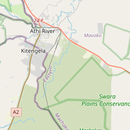
Kitengela on the map
Data Sources & Methodology

Our weather forecasts are powered by a professional weather data provider that aggregates data from national weather services, satellite observations, radar networks, and over 80,000 weather stations worldwide. Forecast data is updated multiple times daily. We convert raw data into clear summaries — wind speed in m/s, pressure in mmHg — so you can plan your day with confidence.