5-day weather forecast Kitengela Nov 20, 2026

25°16° · Patchy rain possible

Weather forecast Kitengela tomorrow Nov 20, 2026: patchy rain possible, temperature from 16 °C to 25 °C.

Precipitation probability 57%. Wind up to 4.19 m/s (gusts 7.53 m/s). Air humidity 58–96%, atmospheric pressure 761–765 mm Hg, UV index up to 12.

Sunrise 06:12
Sunset 18:23
Waxing Gibbous89% illuminated
Moonrise 14:51 · Moonset 02:28
Chart
Table

Forecast from 16 °C to 25 °C and precipitation

Temperature & Precipitation
Time00:0001:0002:0003:0004:0005:0006:0007:0008:0009:0010:0011:0012:0013:0014:0015:0016:0017:0018:0019:0020:0021:0022:0023:00
Temperature (°C)171717171716161719202223242525242322201919181818
Precipitation (mm/hr)0.080.070.070.070.050.040.030.040.040.050.180.240.170.410.830.971.0211.060.60.310.090.090.06

Cloud cover and precipitation probability

Cloud cover & Rain chance
Time00:0001:0002:0003:0004:0005:0006:0007:0008:0009:0010:0011:0012:0013:0014:0015:0016:0017:0018:0019:0020:0021:0022:0023:00
Cloud cover (%)777053696968635876855154848252535961597983798566
Rain chance (%)333133373635322424221920213637415757575546353830

Wind speed and direction

Wind & Wind gust
Time00:0001:0002:0003:0004:0005:0006:0007:0008:0009:0010:0011:0012:0013:0014:0015:0016:0017:0018:0019:0020:0021:0022:0023:00
Wind (m/s)2.112.192.192.1921.811.611.6922.312.813.193.613.814.114.194.113.893.312.892.612.312.312.31
Wind gust (m/s)3.943.973.863.783.443.062.753.364.144.865.365.926.476.837.227.537.337.256.926.195.474.674.644.17
Wind direction (°)ENE 71°ENE 65°ENE 61°ENE 57°ENE 57°ENE 58°NE 55°ENE 58°ENE 63°ENE 63°ENE 64°ENE 68°ENE 73°ENE 78°E 81°E 79°ENE 77°ENE 76°ENE 71°ENE 63°ENE 57°NE 51°NE 52°NE 50°

Air humidity

Humidity
Time00:0001:0002:0003:0004:0005:0006:0007:0008:0009:0010:0011:0012:0013:0014:0015:0016:0017:0018:0019:0020:0021:0022:0023:00
Humidity (%)929494959696969083756863585858606672808589939393

Atmospheric pressure

Pressure
Time00:0001:0002:0003:0004:0005:0006:0007:0008:0009:0010:0011:0012:0013:0014:0015:0016:0017:0018:0019:0020:0021:0022:0023:00
Pressure (mm Hg)764764764764764764764765765765764764763761761761761761761763764764764764

Ultraviolet index

UV Index
Time00:0001:0002:0003:0004:0005:0006:0007:0008:0009:0010:0011:0012:0013:0014:0015:0016:0017:0018:0019:0020:0021:0022:0023:00
UV Index00000000.10.936.810.312119.56.23.51.30.200000

Air quality & pollen

Air quality
Time00:0001:0002:0003:0004:0005:0006:0007:0008:0009:0010:0011:0012:0013:0014:0015:0016:0017:0018:0019:0020:0021:0022:0023:00
PM2.5 (µg/m³)5.55.554.443.745.35.86.16.15.75.25.34.54.54.54.75.47.28.587.36.8
PM10 (µg/m³)6.26.15.64.94.44.14.45.66.26.76.76.35.75.955.155.35.87.68.98.47.67
Ozone (O₃) (µg/m³)434241403836384964778488898884787061534639343233
NO₂ (µg/m³)7.16.66.25.96.16.56.55.84.73.72.821.51.31.423.45.37.18.910.711.611.19.8
SO₂ (µg/m³)44.14.24.34.44.54.755.25.354.54.13.83.53.33.33.53.744.44.74.74.6
CO (µg/m³)196181166157155158169195227245233205186184191203223248262255237225229239

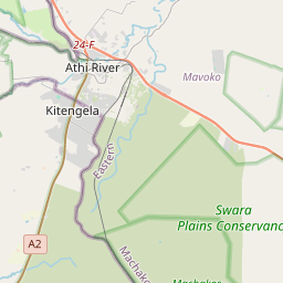
Kitengela on the map

Data Sources & Methodology

Our weather forecasts are powered by a professional weather data provider that aggregates data from national weather services, satellite observations, radar networks, and over 80,000 weather stations worldwide. Forecast data is updated multiple times daily. We convert raw data into clear summaries — wind speed in m/s, pressure in mmHg — so you can plan your day with confidence.