Prognoza pogody na 5 dni Auerbach 20-08-2026
Prognoza pogody Auerbach dziś 20.08.2026: możliwy przelotny deszcz, temperatura od 12 °C do 20 °C.
Prawdopodobieństwo opadów 67%. Wiatr do 5.81 m/s (porywy 14.22 m/s). Wilgotność powietrza 61–99%, ciśnienie atmosferyczne 755–758 mm Hg, indeks UV do 5.1.
Ostrzeżenia pogodowe
Ukryj ostrzeżeniaModerate Thunderstorm Impact
Risk of severe thunderstorms. Possible local property damage and complications, especially in the energy industry and transport. Potential for local flooding, especially of low-lying areas. Local wind damage to roofs, fences, soft shelters and trees. Local power outages. Some travel delays. Driving conditions difficult. Possible crop damage from small hail. Risk of fire caused by lightning strike. Risk of injury from flying or falling objects, and lightning strikes.
Beware of lightning strikes and flying or falling objects (especially branches). Seek shelter in a building equipped with lightning protection. Outdoors, take cover in dense forest or low vegetation; avoid water bodies, hilltops, metal structures, isolated trees, and rock overhangs. When driving reduce speed. Observe weather warnings, weather radar (www.chmi.cz or mobile apps) and local flood risk https://produkty.chmi.cz/ffi.
Moderate Thunderstorm Impact
Risk of severe thunderstorms. Possible local property damage and complications, especially in the energy industry and transport. Potential for local flooding, especially of low-lying areas. Local wind damage to roofs, fences, soft shelters and trees. Local power outages. Some travel delays. Driving conditions difficult. Possible crop damage from small hail. Risk of fire caused by lightning strike. Risk of injury from flying or falling objects, and lightning strikes.
Beware of lightning strikes and flying or falling objects (especially branches). Seek shelter in a building equipped with lightning protection. Outdoors, take cover in dense forest or low vegetation; avoid water bodies, hilltops, metal structures, isolated trees, and rock overhangs. When driving reduce speed. Observe weather warnings, weather radar (www.chmi.cz or mobile apps) and local flood risk https://produkty.chmi.cz/ffi.
Moderate Thunderstorm Impact
Risk of severe thunderstorms. Possible local property damage and complications, especially in the energy industry and transport. Potential for local flooding, especially of low-lying areas. Local wind damage to roofs, fences, soft shelters and trees. Local power outages. Some travel delays. Driving conditions difficult. Possible crop damage from small hail. Risk of fire caused by lightning strike. Risk of injury from flying or falling objects, and lightning strikes.
Beware of lightning strikes and flying or falling objects (especially branches). Seek shelter in a building equipped with lightning protection. Outdoors, take cover in dense forest or low vegetation; avoid water bodies, hilltops, metal structures, isolated trees, and rock overhangs. When driving reduce speed. Observe weather warnings, weather radar (www.chmi.cz or mobile apps) and local flood risk https://produkty.chmi.cz/ffi.
Moderate Thunderstorm Impact
Risk of severe thunderstorms. Possible local property damage and complications, especially in the energy industry and transport. Potential for local flooding, especially of low-lying areas. Local wind damage to roofs, fences, soft shelters and trees. Local power outages. Some travel delays. Driving conditions difficult. Possible crop damage from small hail. Risk of fire caused by lightning strike. Risk of injury from flying or falling objects, and lightning strikes.
Beware of lightning strikes and flying or falling objects (especially branches). Seek shelter in a building equipped with lightning protection. Outdoors, take cover in dense forest or low vegetation; avoid water bodies, hilltops, metal structures, isolated trees, and rock overhangs. When driving reduce speed. Observe weather warnings, weather radar (www.chmi.cz or mobile apps) and local flood risk https://produkty.chmi.cz/ffi.
Moderate Thunderstorm Impact
Risk of severe thunderstorms. Possible local property damage and complications, especially in the energy industry and transport. Potential for local flooding, especially of low-lying areas. Local wind damage to roofs, fences, soft shelters and trees. Local power outages. Some travel delays. Driving conditions difficult. Possible crop damage from small hail. Risk of fire caused by lightning strike. Risk of injury from flying or falling objects, and lightning strikes.
Beware of lightning strikes and flying or falling objects (especially branches). Seek shelter in a building equipped with lightning protection. Outdoors, take cover in dense forest or low vegetation; avoid water bodies, hilltops, metal structures, isolated trees, and rock overhangs. When driving reduce speed. Observe weather warnings, weather radar (www.chmi.cz or mobile apps) and local flood risk https://produkty.chmi.cz/ffi.
5 dni w skrócie — dotknij dnia, aby go otworzyć
Wschód słońca 06:06
Zachód słońca 20:20
Zachód słońca 20:20
Pierwsza kwadra58% oświetlenia
Wschód księżyca 15:58 · Zachód księżyca 23:08
Wykres
Tabelaczw., 20 sie 2026
Prognoza od 12 °C do 20 °C i opady
Zachmurzenie i prawdopodobieństwo opadów
Prędkość i kierunek wiatru
Wilgotność powietrza
Ciśnienie atmosferyczne
Indeks ultrafioletowy
Jakość powietrza i pyłki
czw., 20 sie 2026
Najczęstsze pytania o pogodę na 5 dni w Auerbach
Jaka będzie pogoda w Auerbach w ciągu najbliższych 5 dni?
W ciągu najbliższych 5 dni w Auerbach temperatura wyniesie około od 8 do 21 °C. Szczegółową prognozę godzinową dla każdego z 5 dni znajdziesz na wykresach powyżej.
W które z najbliższych 5 dni będzie padać w Auerbach?
Prawdopodobieństwo opadów w Auerbach w ciągu najbliższych 5 dni sięga 67%. Na wykresie opadów na 5 dni powyżej zobaczysz, w które dni i godziny będzie padać.
Jak dokładna jest prognoza pogody na 5 dni dla Auerbach?
Prognoza na 5 dni jest dość wiarygodna: pierwsze 2–3 dni są zwykle bardzo dokładne, a dni 4–5 mogą zostać skorygowane. Dane są aktualizowane kilka razy dziennie, więc zajrzyj ponownie przed ważnymi planami.
Który z najbliższych 5 dni w Auerbach będzie najcieplejszy, a który najchłodniejszy?
W ciągu najbliższych 5 dni temperatura w Auerbach waha się od około 8 do 21 °C. Najcieplejszy i najchłodniejszy dzień porównasz na wykresie temperatury powyżej.
Czy w Auerbach w ciągu najbliższych 5 dni będzie wietrznie?
W ciągu najbliższych 5 dni wiatr w Auerbach wzmaga się do 6 m/s. Najbardziej wietrzne dni łatwo dostrzec na wykresie wiatru powyżej.
Który dzień tygodnia w Auerbach najlepiej nadaje się na spacer lub wyjazd?
Na spacer lub wyjazd wybierz dni z najmniejszym prawdopodobieństwem opadów (do 67%) i słabym wiatrem — łatwo je porównać na wykresach na 5 dni powyżej.
Jak najlepiej korzystać z prognozy na 5 dni dla Auerbach?
Pierwsze 2–3 dni są wystarczająco wiarygodne do konkretnych decyzji, a dni 4–5 są wskazówką, która uściśla się w miarę zbliżania. Prognoza jest aktualizowana kilka razy dziennie, więc sprawdź ją ponownie przed ważnymi planami.
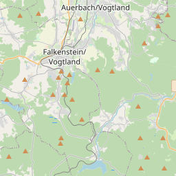
Auerbach na mapie
Źródła danych i metodologia
Nasze prognozy pogody są zasilane przez profesjonalnego dostawcę danych pogodowych, który agreguje dane z krajowych służb meteorologicznych, obserwacji satelitarnych, sieci radarowych i ponad 80 000 stacji meteorologicznych na całym świecie. Dane prognostyczne są aktualizowane wielokrotnie w ciągu dnia. Przetwarzamy surowe dane na czytelne podsumowania — prędkość wiatru w m/s, ciśnienie w mm Hg — abyście Państwo mogli planować dzień z pewnością.