Pronóstico del tiempo a 5 días Auerbach 22-08-2026

Pronóstico del tiempo Auerbach mañana 22.08.2026: chubasco de lluvia ligera, temperatura de 8 °C a 14 °C.

Probabilidad de precipitaciones 84%. Viento de hasta 5.31 m/s (ráfagas 10.53 m/s). Humedad del aire 64–97%, presión atmosférica 759–766 mm Hg, índice UV de hasta 3.7.

Alertas meteorológicas

Ocultar alertas
Severe20 ago, 18:1022 ago, 01:59Traducir con Google
Major Thunderstorm Impact
Risk of very severe thunderstorms with torrential rain (around 40 mm in a short time), in combination with rain around 70 mm, wind gusts 20 to 25 m/s (70 to 90 km/h) and hail around 2 cm. Local property damage and complications, especially in the energy industry, transport, and agriculture. Potential for dangerous flooding, flash floods. Increased runoff from slopes, rapid flooding of low-lying areas, dry gullies, small streams, undercutting of roads. Significant wind damage to trees, parks, buildings, property, energy infrastructure etc. Power outages. Travel delays and disruptions. Driving conditions difficult due to wind gusts, reduced visibility, fallen trees/branches, high risk of hydroplaning. Extensive damage to vegetation, buildings, and property from hail. Risk of fire caused by lightning strike. Risk of serious injury from flying or falling objects and lightning strikes.
Beware of lightning strikes, hail, and falling or windblown objects. Seek shelter in a building with lightning protection. Outdoors, take cover in dense forest or low vegetation; avoid water, hilltops, metal structures, isolated trees, and rock overhangs. Avoid stream courses in the mountains, as water and debris flows may occur there suddenly. Secure windows, doors, greenhouses, and loose objects. Be prepared for possible power outages. When driving, reduce speed, do not enter or drive into flowing water or flooded areas. Stay informed of the driving conditions. Observe weather warnings, weather radar (www.chmi.cz or mobile apps) and flash flood risk https://produkty.chmi.cz/ffi.
Moderate20 ago, 18:1022 ago, 01:59Traducir con Google
Moderate Thunderstorm Impact
Risk of severe thunderstorms with torrential rain (around 40 mm in a short time), wind gusts up to 20 m/s (70 km/h) and hail up to 2 cm. Possible local property damage and complications, especially in the energy industry and transport. Potential for local flooding, especially of low-lying areas. Local wind damage to roofs, fences, soft shelters and trees. Local power outages. Some travel delays. Driving conditions difficult. Possible crop damage from small hail. Risk of fire caused by lightning strike. Risk of injury from flying or falling objects, and lightning strikes.
Beware of lightning strikes and flying or falling objects (especially branches). Seek shelter in a building equipped with lightning protection. Outdoors, take cover in dense forest or low vegetation; avoid water bodies, hilltops, metal structures, isolated trees, and rock overhangs. When driving reduce speed. Observe weather warnings, weather radar (www.chmi.cz or mobile apps) and local flood risk https://produkty.chmi.cz/ffi.
Severe20 ago, 18:1022 ago, 01:59Traducir con Google
Major Thunderstorm Impact
Risk of very severe thunderstorms with torrential rain (around 40 mm in a short time), in combination with rain around 70 mm, wind gusts 20 to 25 m/s (70 to 90 km/h) and hail around 2 cm. Local property damage and complications, especially in the energy industry, transport, and agriculture. Potential for dangerous flooding, flash floods. Increased runoff from slopes, rapid flooding of low-lying areas, dry gullies, small streams, undercutting of roads. Significant wind damage to trees, parks, buildings, property, energy infrastructure etc. Power outages. Travel delays and disruptions. Driving conditions difficult due to wind gusts, reduced visibility, fallen trees/branches, high risk of hydroplaning. Extensive damage to vegetation, buildings, and property from hail. Risk of fire caused by lightning strike. Risk of serious injury from flying or falling objects and lightning strikes.
Beware of lightning strikes, hail, and falling or windblown objects. Seek shelter in a building with lightning protection. Outdoors, take cover in dense forest or low vegetation; avoid water, hilltops, metal structures, isolated trees, and rock overhangs. Avoid stream courses in the mountains, as water and debris flows may occur there suddenly. Secure windows, doors, greenhouses, and loose objects. Be prepared for possible power outages. When driving, reduce speed, do not enter or drive into flowing water or flooded areas. Stay informed of the driving conditions. Observe weather warnings, weather radar (www.chmi.cz or mobile apps) and flash flood risk https://produkty.chmi.cz/ffi.
Moderate20 ago, 18:1022 ago, 01:59Traducir con Google
Moderate Thunderstorm Impact
Risk of severe thunderstorms with torrential rain (around 40 mm in a short time), wind gusts up to 20 m/s (70 km/h) and hail up to 2 cm. Possible local property damage and complications, especially in the energy industry and transport. Potential for local flooding, especially of low-lying areas. Local wind damage to roofs, fences, soft shelters and trees. Local power outages. Some travel delays. Driving conditions difficult. Possible crop damage from small hail. Risk of fire caused by lightning strike. Risk of injury from flying or falling objects, and lightning strikes.
Beware of lightning strikes and flying or falling objects (especially branches). Seek shelter in a building equipped with lightning protection. Outdoors, take cover in dense forest or low vegetation; avoid water bodies, hilltops, metal structures, isolated trees, and rock overhangs. When driving reduce speed. Observe weather warnings, weather radar (www.chmi.cz or mobile apps) and local flood risk https://produkty.chmi.cz/ffi.
Severe20 ago, 18:1022 ago, 01:59Traducir con Google
Major Thunderstorm Impact
Risk of very severe thunderstorms with torrential rain (around 40 mm in a short time), in combination with rain around 70 mm, wind gusts 20 to 25 m/s (70 to 90 km/h) and hail around 2 cm. Local property damage and complications, especially in the energy industry, transport, and agriculture. Potential for dangerous flooding, flash floods. Increased runoff from slopes, rapid flooding of low-lying areas, dry gullies, small streams, undercutting of roads. Significant wind damage to trees, parks, buildings, property, energy infrastructure etc. Power outages. Travel delays and disruptions. Driving conditions difficult due to wind gusts, reduced visibility, fallen trees/branches, high risk of hydroplaning. Extensive damage to vegetation, buildings, and property from hail. Risk of fire caused by lightning strike. Risk of serious injury from flying or falling objects and lightning strikes.
Beware of lightning strikes, hail, and falling or windblown objects. Seek shelter in a building with lightning protection. Outdoors, take cover in dense forest or low vegetation; avoid water, hilltops, metal structures, isolated trees, and rock overhangs. Avoid stream courses in the mountains, as water and debris flows may occur there suddenly. Secure windows, doors, greenhouses, and loose objects. Be prepared for possible power outages. When driving, reduce speed, do not enter or drive into flowing water or flooded areas. Stay informed of the driving conditions. Observe weather warnings, weather radar (www.chmi.cz or mobile apps) and flash flood risk https://produkty.chmi.cz/ffi.
Los 5 días de un vistazo — toca un día para abrirlo
Amanecer 06:09
Atardecer 20:16
Gibosa creciente78% iluminada
Salida de la luna 17:55 · Puesta de la luna Does not set today
Gráfico
Tabla

Pronóstico de 8 °C a 14 °C y precipitaciones

Temperatura & Precipitaciones
Hora00:0001:0002:0003:0004:0005:0006:0007:0008:0009:0010:0011:0012:0013:0014:0015:0016:0017:0018:0019:0020:0021:0022:0023:00
Temperatura (°C)9101099999989912911121313121314131312
Precipitaciones (mm/h)0.0102.250.20.120.280.470.410.621.840.290.890.650.790.220.180.120.390.120.080.020.020.010.02

Nubosidad y probabilidad de precipitaciones

Nubosidad & Probabilidad de lluvia
Hora00:0001:0002:0003:0004:0005:0006:0007:0008:0009:0010:0011:0012:0013:0014:0015:0016:0017:0018:0019:0020:0021:0022:0023:00
Nubosidad (%)10010010097971001001001001001001001001009110078100989785807079
Probabilidad de lluvia (%)443884484454646168815372627138332038302921252435

Velocidad y dirección del viento

Viento & Ráfaga de viento
Hora00:0001:0002:0003:0004:0005:0006:0007:0008:0009:0010:0011:0012:0013:0014:0015:0016:0017:0018:0019:0020:0021:0022:0023:00
Viento (m/s)22.893.53.394.1143.3135.194.392.612.395.313.194.1943.53.693.313.112.191.691.611.31
Ráfaga de viento (m/s)7.039.221010.4210.539.337.817.319.119.839.118.729.4276.726.146.036.427.537.926.311.831.611.42
Dirección del viento (°)SO 223°SO 222°SO 220°SO 219°SO 223°SO 232°OSO 241°SO 233°OSO 254°O 262°O 269°OSO 258°ONO 288°ONO 293°ONO 300°NO 308°NO 304°ONO 294°O 278°O 276°O 272°O 261°OSO 247°SO 231°

Humedad del aire

Humedad
Hora00:0001:0002:0003:0004:0005:0006:0007:0008:0009:0010:0011:0012:0013:0014:0015:0016:0017:0018:0019:0020:0021:0022:0023:00
Humedad (%)979595959697979696959391849481736464747779879195

Presión atmosférica

Presión
Hora00:0001:0002:0003:0004:0005:0006:0007:0008:0009:0010:0011:0012:0013:0014:0015:0016:0017:0018:0019:0020:0021:0022:0023:00
Presión (mm Hg)760760760760760759759760761761761761761762762762763763764764764765766766

Índice ultravioleta

Índice UV
Hora00:0001:0002:0003:0004:0005:0006:0007:0008:0009:0010:0011:0012:0013:0014:0015:0016:0017:0018:0019:0020:0021:0022:0023:00
Índice UV00000000.10.10.10.71.92.33.73.13.32.50.70.70.20000

Calidad del aire y polen

Calidad del aire
Hora00:0001:0002:0003:0004:0005:0006:0007:0008:0009:0010:0011:0012:0013:0014:0015:0016:0017:0018:0019:0020:0021:0022:0023:00
PM2.5 (µg/m³)5.35.155.14.95.65.25.45.24.64.33.83.32.931.621.922.32.83.63.83.6
PM10 (µg/m³)7.67.47.66.87.46.576.46.96.34.94.43.73.23.21.82.22.12.53.24.34.85.36.1
Ozono (O₃) (µg/m³)545755595857555553556162646867697274727069646059
NO₂ (µg/m³)4.84.13.73.63.43.63.53.63.42.72.11.81.81.41.21.210.90.91.21.62.33.12.9
SO₂ (µg/m³)0.20.20.10.10.10.10.10.20.20.20.20.20.20.20.20.20.10.10.10.10.20.20.20.2
CO (µg/m³)152151146147150152155158155153149147141143150148139140140143142142142145

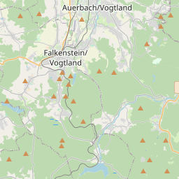
Auerbach en el mapa

Fuentes de datos y metodología

Nuestros pronósticos meteorológicos se basan en un proveedor profesional de datos meteorológicos que agrega datos de servicios meteorológicos nacionales, observaciones satelitales, redes de radar y más de 80 000 estaciones meteorológicas en todo el mundo. Los datos de pronóstico se actualizan varias veces al día. Convertimos los datos en bruto en resúmenes claros — velocidad del viento en m/s, presión en mm Hg — para que pueda planificar su día con confianza.