
Pronóstico del tiempo a 5 días Auerbach 22 oct 2026
 10°
10°Pronóstico del tiempo Auerbach mañana 22 oct 2026: soleado, temperatura de 5 °C a 10 °C.
Probabilidad de precipitaciones 78%. Viento de hasta 6.19 m/s (ráfagas 12.53 m/s). Humedad del aire 58–96%, presión atmosférica 761–766 mm Hg, índice UV de hasta 1.1.
Alertas meteorológicas
Moderate Wind Related Impact
SE wind with gusts between 15 and 20 m/s (55 to 70 km/h).
Possible complications in the energy industry, forestry, and transport. Possible damage to trees and forests. Minor damage to energy infrastructure, property (especially older buildings). Risk of injury from flying or falling objects, especially broken branches. Minor travel delays due to debris and outages.
Secure windows, doors, remove or anchor loosely stored objects, tents, greenhouses, etc. Watch out for falling objects such as branches or roof tiles. When driving, watch out for strong crosswinds at exposed points such as bridges, drive slowly. In the mountains, limit hikes and avoid ridge areas in particular.
Moderate Wind Related Impact
SE wind with gusts between 15 and 20 m/s (55 to 70 km/h).
Possible complications in the energy industry, forestry, and transport. Possible damage to trees and forests. Minor damage to energy infrastructure, property (especially older buildings). Risk of injury from flying or falling objects, especially broken branches. Minor travel delays due to debris and outages.
Secure windows, doors, remove or anchor loosely stored objects, tents, greenhouses, etc. Watch out for falling objects such as branches or roof tiles. When driving, watch out for strong crosswinds at exposed points such as bridges, drive slowly. In the mountains, limit hikes and avoid ridge areas in particular.
Moderate Wind Related Impact
SE wind with gusts between 15 and 20 m/s (55 to 70 km/h).
Possible complications in the energy industry, forestry, and transport. Possible damage to trees and forests. Minor damage to energy infrastructure, property (especially older buildings). Risk of injury from flying or falling objects, especially broken branches. Minor travel delays due to debris and outages.
Secure windows, doors, remove or anchor loosely stored objects, tents, greenhouses, etc. Watch out for falling objects such as branches or roof tiles. When driving, watch out for strong crosswinds at exposed points such as bridges, drive slowly. In the mountains, limit hikes and avoid ridge areas in particular.
Moderate Wind Related Impact
SE wind with gusts between 15 and 20 m/s (55 to 70 km/h).
Possible complications in the energy industry, forestry, and transport. Possible damage to trees and forests. Minor damage to energy infrastructure, property (especially older buildings). Risk of injury from flying or falling objects, especially broken branches. Minor travel delays due to debris and outages.
Secure windows, doors, remove or anchor loosely stored objects, tents, greenhouses, etc. Watch out for falling objects such as branches or roof tiles. When driving, watch out for strong crosswinds at exposed points such as bridges, drive slowly. In the mountains, limit hikes and avoid ridge areas in particular.
Los 5 días de un vistazo — toca un día para abrirlo
Amanecer 07:44
Atardecer 18:04
Atardecer 18:04
Gibosa creciente92% iluminada
Salida de la luna 16:34 · Puesta de la luna 03:20
Salida de la luna 16:34 · Puesta de la luna 03:20
Gráfico
Tabla
| Hora | Tiempo | Temperatura | Probabilidad de lluvia | Nubosidad | Humedad | Presión | Viento | Índice UV |
|---|---|---|---|---|---|---|---|---|
| 00:00 |  Lluvia ligera | 7 °C | 78% (1.16 mm/h) | 100% | 95% | 761 mm Hg | OSO 241° 4.89 (10.61) m/s | 0 |
| 01:00 |  Llovizna ligera | 7 °C | 52% (0.16 mm/h) | 100% | 94% | 761 mm Hg | OSO 246° 5.39 (10.81) m/s | 0 |
| 02:00 |  Chubasco de lluvia ligera | 7 °C | 47% (0.16 mm/h) | 100% | 96% | 761 mm Hg | OSO 246° 5.39 (10.03) m/s | 0 |
| 03:00 |  Posible lluvia dispersa | 6 °C | 31% (0.01 mm/h) | 100% | 90% | 762 mm Hg | OSO 252° 5.61 (11.39) m/s | 0 |
| 04:00 | Posible lluvia dispersa | 6 °C | 33% (0.02 mm/h) | 100% | 91% | 763 mm Hg | OSO 248° 5.61 (11.19) m/s | 0 |
| 05:00 | Posible lluvia dispersa | 5 °C | 31% (0.01 mm/h) | 100% | 90% | 764 mm Hg | OSO 247° 5.69 (11.31) m/s | 0 |
| 06:00 |  Cubierto | 5 °C | 30% | 100% | 90% | 764 mm Hg | OSO 245° 5.31 (11) m/s | 0 |
| 07:00 |  Nublado | 5 °C | 25% | 83% | 88% | 764 mm Hg | OSO 238° 5.19 (10.72) m/s | 0 |
| 08:00 |  Nublado | 5 °C | 20% | 67% | 86% | 765 mm Hg | SO 234° 5.61 (11.31) m/s | 0 |
| 09:00 |  Parcialmente nublado | 5 °C | 15% | 34% | 86% | 765 mm Hg | SO 226° 5.61 (12.11) m/s | 0.1 |
| 10:00 | Parcialmente nublado | 5 °C | 19% | 59% | 85% | 765 mm Hg | SO 231° 5.81 (12.5) m/s | 0.3 |
| 11:00 | Parcialmente nublado | 6 °C | 16% | 57% | 81% | 766 mm Hg | SO 233° 6 (12.53) m/s | 0.7 |
| 12:00 | Soleado | 7 °C | 9% | 19% | 75% | 765 mm Hg | SO 232° 5.89 (11.53) m/s | 0.9 |
| 13:00 | Soleado | 9 °C | 5% | 5% | 65% | 764 mm Hg | SO 235° 6.19 (10.42) m/s | 1.1 |
| 14:00 | Soleado | 10 °C | 4% | 5% | 59% | 764 mm Hg | SO 236° 6.11 (9.64) m/s | 1.1 |
| 15:00 | Soleado | 10 °C | 3% | 4% | 58% | 764 mm Hg | SO 236° 5.81 (9.92) m/s | 0.5 |
| 16:00 | Soleado | 10 °C | 4% | 1% | 61% | 764 mm Hg | SO 235° 5.39 (9.89) m/s | 0.3 |
| 17:00 | Soleado | 9 °C | 5% | 4% | 66% | 764 mm Hg | SO 235° 5.11 (10.22) m/s | 0 |
| 18:00 | Parcialmente nublado | 7 °C | 9% | 30% | 73% | 765 mm Hg | SO 224° 4.19 (10.11) m/s | 0 |
| 19:00 | Cubierto | 6 °C | 23% | 100% | 78% | 766 mm Hg | SSO 205° 3.61 (10.42) m/s | 0 |
| 20:00 | Cubierto | 8 °C | 21% | 100% | 74% | 766 mm Hg | SSO 213° 4.31 (10.61) m/s | 0 |
| 21:00 | Cubierto | 8 °C | 22% | 100% | 76% | 766 mm Hg | SSO 213° 4.31 (10.83) m/s | 0 |
| 22:00 | Posible lluvia dispersa | 8 °C | 22% (0.01 mm/h) | 100% | 76% | 766 mm Hg | SO 216° 4.19 (10.72) m/s | 0 |
| 23:00 | Cubierto | 8 °C | 20% | 95% | 75% | 766 mm Hg | SSO 210° 3.81 (10.33) m/s | 0 |
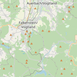
Auerbach en el mapa
Fuentes de datos y metodología
Nuestros pronósticos meteorológicos se basan en un proveedor profesional de datos meteorológicos que agrega datos de servicios meteorológicos nacionales, observaciones satelitales, redes de radar y más de 80 000 estaciones meteorológicas en todo el mundo. Los datos de pronóstico se actualizan varias veces al día. Convertimos los datos en bruto en resúmenes claros — velocidad del viento en m/s, presión en mm Hg — para que pueda planificar su día con confianza.