
5-day weather forecast Charleston Nov 17, 2026
 16°
Weather forecast Charleston Tuesday Nov 17, 2026: partly cloudy, temperature from 8 °C to 16 °C.
Precipitation probability 15%. Wind up to 4.19 m/s (gusts 10.64 m/s). Air humidity 52–72%, atmospheric pressure 773–774 mm Hg, UV index up to 3.4.
Weather Alerts
Freeze Watch issued November 13 at 1:18PM EST until November 15 at 9:00AM EST by NWS Charleston SC
Freeze Watch
* WHAT...For the Frost Advisory, temperatures as low as 34 will
result in frost formation. For the Freeze Watch, sub-freezing
temperatures as low as 30 possible.
* WHERE...Portions of southeast Georgia and southeast South Carolina.
* WHEN...For the Frost Advisory, from 2 AM to 8 AM EST Saturday. For
the Freeze Watch, from late Saturday night through Sunday morning.
* IMPACTS...Frost and freeze conditions could kill crops, other
sensitive vegetation and possibly damage unprotected outdoor
plumbing. Frost could harm sensitive outdoor vegetation. Sensitive
outdoor plants may be killed if left uncovered.
Frost Advisory issued November 13 at 1:18PM EST until November 14 at 8:00AM EST by NWS Charleston SC
Frost Advisory
* WHAT...For the Frost Advisory, temperatures as low as 34 will
result in frost formation. For the Freeze Watch, sub-freezing
temperatures as low as 30 possible.
* WHERE...Portions of southeast Georgia and southeast South Carolina.
* WHEN...For the Frost Advisory, from 2 AM to 8 AM EST Saturday. For
the Freeze Watch, from late Saturday night through Sunday morning.
* IMPACTS...Frost and freeze conditions could kill crops, other
sensitive vegetation and possibly damage unprotected outdoor
plumbing. Frost could harm sensitive outdoor vegetation. Sensitive
outdoor plants may be killed if left uncovered.
5 days at a glance — tap a day to open it
Sunrise 06:51
Sunset 17:17
Sunset 17:17
First Quarter63% illuminated
Moonrise 13:16 · Moonset does not set today
Moonrise 13:16 · Moonset does not set today
Chart
TableTue, Nov 17, 2026
Forecast from 8 °C to 16 °C and precipitation
Cloud cover and precipitation probability
Wind speed and direction
Air humidity
Atmospheric pressure
Ultraviolet index
Air quality & pollen
Air quality is available for the first three days only.
Tue, Nov 17, 2026
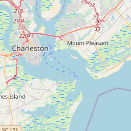
Charleston on the map
Data Sources & Methodology
Our weather forecasts are powered by a professional weather data provider that aggregates data from national weather services, satellite observations, radar networks, and over 80,000 weather stations worldwide. Forecast data is updated multiple times daily. We convert raw data into clear summaries — wind speed in m/s, pressure in mmHg — so you can plan your day with confidence.