
5-day weather forecast Grožnjan Oct 11, 2026
 20°
20°Weather forecast Grožnjan today Oct 11, 2026: overcast, temperature from 18 °C to 20 °C.
Precipitation probability 70%. Wind up to 5.81 m/s (gusts 7.53 m/s). Air humidity 57–81%, atmospheric pressure 758–760 mm Hg, UV index up to 2.9.
Weather Alerts
Moderate Thunderstorms Warning (Degree 2/4) - Slovenia / South-West
Moderate Thunderstorms Warning
Thunderstorms are possible, accompanied by local intense precipitation and gusty winds. Intense local showers with wind blasts and lightning strikes are possible. Torrential watercourses may rise quickly. Rainwater floods are possible.
Beware of approaching storm clouds. Do not linger in exposed locations, e.g. under trees or power lines. Wait in a safe place, as storms usually do not last long.
Moderate Wind Warning (Degree 2/4) - Slovenia / South-West
Moderate Wind Warning
Maximum wind speed : from 70 to 85 km/h. Wind sways trees and may break branches. It impedes road traffic of certain categories and may hinder movement to some extent. The sea is fairly rough (3).
Before the event:
Close all windows and doors. Stow or fasten anything that could be carried away by the wind. Check the situation of vessels in berths.
During the event:
Doors and windows should be kept closed. When moving in the open, pay attention to possible falling objects. Stop all work at heights. Do not repair damage during the event. We recommend additional caution in traffic, especially in crosswinds and in exposed areas (e.g. bridges, cuttings). Caution is recommended in water sports. Less skilled sailors should not sail out. Swimmers should stay close to the shore.
Yellow wind warning
Strong bura (NE wind) with gale force gusts.
STAY ALERT for debris carried by strong winds. Debris and tree branches carried by the wind may cause localised interruptions in outdoor activities.
5 days at a glance — tap a day to open it
Sunrise 07:16
Sunset 18:27
Sunset 18:27
New Moon1% illuminated
Moonrise 08:10 · Moonset 18:24
Moonrise 08:10 · Moonset 18:24
Chart
Table
Sun, Oct 11, 2026
| Time | Weather | Temperature | Rain chance | Cloud cover | Humidity | Pressure | Wind | UV Index |
|---|---|---|---|---|---|---|---|---|
| 00:00 |  Light rain shower | 19 °C | 70% (1.77 mm/hr) | 100% | 76% | 758 mm Hg | ENE 70° 2.19 (6.19) m/s | 0 |
| 01:00 | Light rain shower | 19 °C | 56% (0.6 mm/hr) | 100% | 78% | 758 mm Hg | ENE 72° 3.39 (3.42) m/s | 0 |
| 02:00 | Light rain shower | 18 °C | 37% (0.16 mm/hr) | 100% | 81% | 758 mm Hg | SE 124° 5.81 (6.31) m/s | 0 |
| 03:00 |  Light drizzle | 18 °C | 42% (0.17 mm/hr) | 100% | 80% | 758 mm Hg | ESE 119° 5.69 (7.33) m/s | 0 |
| 04:00 |  Patchy rain possible | 18 °C | 31% (0.12 mm/hr) | 100% | 76% | 758 mm Hg | ESE 119° 5.31 (7.53) m/s | 0 |
| 05:00 |  Overcast | 18 °C | 20% | 100% | 73% | 758 mm Hg | ESE 104° 3.61 (4.42) m/s | 0 |
| 06:00 | Overcast | 18 °C | 19% | 100% | 72% | 758 mm Hg | ENE 76° 1.11 (2) m/s | 0 |
| 07:00 | Overcast | 18 °C | 18% | 100% | 70% | 758 mm Hg | NNW 333° 1.81 (2.81) m/s | 0 |
| 08:00 |  Cloudy | 18 °C | 12% | 67% | 69% | 758 mm Hg | NNE 25° 0.81 (1.42) m/s | 0 |
| 09:00 | Overcast | 18 °C | 17% | 100% | 68% | 759 mm Hg | WSW 238° 1.11 (1.81) m/s | 0.3 |
| 10:00 | Overcast | 19 °C | 16% | 100% | 66% | 759 mm Hg | S 174° 2.5 (4.14) m/s | 1.1 |
| 11:00 |  Partly cloudy | 19 °C | 7% | 39% | 64% | 759 mm Hg | S 169° 3.69 (4.31) m/s | 2.1 |
| 12:00 | Partly cloudy | 20 °C | 6% | 38% | 61% | 759 mm Hg | SSE 152° 2.69 (3.11) m/s | 2.8 |
| 13:00 | Partly cloudy | 20 °C | 6% | 38% | 58% | 759 mm Hg | ESE 115° 1 (2) m/s | 2.9 |
| 14:00 |  Sunny | 20 °C | 4% | 24% | 57% | 758 mm Hg | NNE 28° 1 (1.92) m/s | 2.6 |
| 15:00 | Sunny | 20 °C | 4% | 10% | 58% | 758 mm Hg | NNE 15° 2.19 (2.64) m/s | 2.2 |
| 16:00 | Overcast | 20 °C | 14% | 100% | 58% | 758 mm Hg | NNE 18° 2.39 (2.72) m/s | 1.3 |
| 17:00 | Overcast | 20 °C | 13% | 100% | 57% | 758 mm Hg | E 95° 0.61 (1.5) m/s | 0.5 |
| 18:00 | Overcast | 20 °C | 14% | 100% | 57% | 758 mm Hg | SE 124° 2.5 (2.81) m/s | 0.1 |
| 19:00 | Overcast | 20 °C | 14% | 100% | 57% | 759 mm Hg | SE 128° 3.5 (3.83) m/s | 0 |
| 20:00 | Overcast | 19 °C | 14% | 100% | 59% | 759 mm Hg | ESE 117° 3.5 (4.22) m/s | 0 |
| 21:00 | Overcast | 18 °C | 15% | 100% | 60% | 759 mm Hg | E 97° 3.5 (4.03) m/s | 0 |
| 22:00 | Overcast | 18 °C | 15% | 100% | 62% | 760 mm Hg | E 100° 3.5 (4) m/s | 0 |
| 23:00 | Overcast | 18 °C | 15% | 100% | 63% | 760 mm Hg | ESE 106° 3.39 (3.72) m/s | 0 |
Sun, Oct 11, 2026
Frequently asked questions about the 5-day weather in Grožnjan
What will the weather be like in Grožnjan over the next 5 days?
Over the next 5 days in Grožnjan the temperature is expected to range from about 13 to 20 °C. See the detailed hourly forecast for each of the 5 days in the charts above.
On which of the next 5 days will it rain in Grožnjan?
The chance of rain in Grožnjan over the next 5 days reaches 88%. Check the 5-day precipitation chart above to see exactly which days and hours bring rain.
How accurate is the 5-day weather forecast for Grožnjan?
A 5-day forecast is fairly reliable: the first 2–3 days are usually very accurate, while days 4–5 may be refined. The data is updated several times a day, so check back before important plans.
Which of the next 5 days in Grožnjan will be the warmest and which the coolest?
Over the next 5 days the temperature in Grožnjan ranges from about 13 to 20 °C. Compare the warmest and coolest day on the temperature chart above.
Will it be windy in Grožnjan over the next 5 days?
Over the next 5 days the wind in Grožnjan picks up to 6 m/s. The windiest days are easy to spot on the wind chart above.
Which day of the week in Grožnjan is best for a walk or a trip?
For a walk or a trip, pick the days with the lowest chance of rain (up to 88%) and light wind — easy to compare on the 5-day charts above.
How can I best use the 5-day forecast for Grožnjan?
The first 2–3 days are reliable enough for firm decisions, while days 4–5 are a guide that sharpens as they approach. The forecast is updated several times a day, so check again before important plans.
Will I need an umbrella or sunscreen in Grožnjan this week?
Rain reaches a 88% chance across the next 5 days, so pack something waterproof for the wettest of them — the daily strip above shows which. Today’s UV index peaks at 2.9; sunscreen is worth it from about 3 upwards.
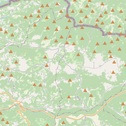
Grožnjan on the map
Data Sources & Methodology
Our weather forecasts are powered by a professional weather data provider that aggregates data from national weather services, satellite observations, radar networks, and over 80,000 weather stations worldwide. Forecast data is updated multiple times daily. We convert raw data into clear summaries — wind speed in m/s, pressure in mmHg — so you can plan your day with confidence.