
Pronóstico del tiempo a 5 días Iisalmi 14 nov 2026

-1°-2° · Nieve moderada

Pronóstico del tiempo Iisalmi sábado 14 nov 2026: nieve moderada, temperatura de -2 °C a -1 °C.

Probabilidad de precipitaciones 71%. Viento de hasta 6 m/s (ráfagas 11.42 m/s). Humedad del aire 87–98%, presión atmosférica 735–746 mm Hg, índice UV de hasta 0.1.

Alertas meteorológicas

Moderate11 nov, 00:00 — 12 nov, 00:00Traducir con Google
Yellow traffic weather warning: Locally in the middle part of the country, Wed 0.00 - Thu 0.00

Traffic weather warning

Traffic weather warning: Bad road conditions are expected at first because of snow or sleet.
Moderate14 nov, 00:00 — 15 nov, 00:00Traducir con Google
Yellow traffic weather warning: The middle and locally in northern parts of the country, Sat 0.00 - Sun 0.00

Traffic weather warning

Traffic weather warning: From the night between Friday and Saturday to the night between Saturday and Sunday, probability for bad road conditions is 30% because of snow or sleet.
Moderate12 nov, 00:00 — 13 nov, 00:00Traducir con Google
Yellow traffic weather warning: Locally in the middle and northern parts of the country, Thu 0.00 - Fri 0.00

Traffic weather warning

Traffic weather warning: From the night between Wednesday and Thursday to the night between Thursday and Friday, probability for bad road conditions is 40% because of snow or sleet.
Moderate13 nov, 00:00 — 14 nov, 00:00Traducir con Google
Yellow traffic weather warning: Locally in over the whole country, Fri 0.00 - Sat 0.00

Traffic weather warning

Traffic weather warning: From the night between Thursday and Friday to the night between Friday and Saturday, probability for bad road conditions is 60% because of snow or sleet.
Moderate11 nov, 00:09 — 12 nov, 00:00Traducir con Google
Yellow traffic weather warning: Locally in the middle part of the country, Wed 0.09 - Thu 0.00

Traffic weather warning

Traffic weather warning: Bad road conditions are expected at first because of snow or sleet.
Los 5 días de un vistazo — toca un día para abrirlo
Amanecer 08:32
Atardecer 15:19
Cuarto creciente31% iluminada
Salida de la luna 14:36 · Puesta de la luna 18:29
Gráfico
Tabla

Pronóstico de -2 °C a -1 °C y precipitaciones

Temperatura & Precipitaciones
Hora00:0001:0002:0003:0004:0005:0006:0007:0008:0009:0010:0011:0012:0013:0014:0015:0016:0017:0018:0019:0020:0021:0022:0023:00
Temperatura (°C)000000000-1-1-1-2-2-2-1-1-1-1-1-1-1-1-2
Precipitaciones (mm/h)0.440.430.490.10.050.040.050.080.270.250.150.120.110.090.060.060.080.080.070.050.020.010.010

Nubosidad y probabilidad de precipitaciones

Nubosidad & Probabilidad de lluvia
Hora00:0001:0002:0003:0004:0005:0006:0007:0008:0009:0010:0011:0012:0013:0014:0015:0016:0017:0018:0019:0020:0021:0022:0023:00
Nubosidad (%)100100100100100100100100100100100100999998100100100100100100795740
Probabilidad de lluvia (%)686871484038394459574744434235353941373531242017

Velocidad y dirección del viento

Viento & Ráfaga de viento
Hora00:0001:0002:0003:0004:0005:0006:0007:0008:0009:0010:0011:0012:0013:0014:0015:0016:0017:0018:0019:0020:0021:0022:0023:00
Viento (m/s)1.891.51.110.611.111.692.112.312.813.894.615.195.195.315.55.695.815.896665.815.395.11
Ráfaga de viento (m/s)6.816.175.475.314.53.893.53.114.428.6110.1110.039.831111.4211.4210.8310.9211.0310.8111.1911.3111.3110.81
Dirección del viento (°)E 83°ENE 75°ENE 62°O 276°O 274°O 270°O 274°O 275°ONO 282°ONO 297°ONO 298°ONO 298°ONO 296°ONO 294°ONO 294°ONO 293°ONO 288°ONO 285°ONO 283°O 280°O 278°O 276°O 272°O 266°

Humedad del aire

Humedad
Hora00:0001:0002:0003:0004:0005:0006:0007:0008:0009:0010:0011:0012:0013:0014:0015:0016:0017:0018:0019:0020:0021:0022:0023:00
Humedad (%)969797989897979696949290909088878990898988878787

Presión atmosférica

Presión
Hora00:0001:0002:0003:0004:0005:0006:0007:0008:0009:0010:0011:0012:0013:0014:0015:0016:0017:0018:0019:0020:0021:0022:0023:00
Presión (mm Hg)736736735735735735735735735736737737737738739740740741742743743744745746

Índice ultravioleta

Índice UV
Hora00:0001:0002:0003:0004:0005:0006:0007:0008:0009:0010:0011:0012:0013:0014:0015:0016:0017:0018:0019:0020:0021:0022:0023:00
Índice UV000000000000.10.10.10000000000

Calidad del aire y polen

La calidad del aire solo está disponible para los tres primeros días.

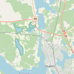
Iisalmi en el mapa
Fuentes de datos y metodología

Nuestros pronósticos meteorológicos se basan en un proveedor profesional de datos meteorológicos que agrega datos de servicios meteorológicos nacionales, observaciones satelitales, redes de radar y más de 80 000 estaciones meteorológicas en todo el mundo. Los datos de pronóstico se actualizan varias veces al día. Convertimos los datos en bruto en resúmenes claros — velocidad del viento en m/s, presión en mm Hg — para que pueda planificar su día con confianza.