
5-day weather forecast Sefton Nov 9, 2026

20°8° · Sunny

Weather forecast Sefton Monday Nov 9, 2026: sunny, temperature from 8 °C to 20 °C.

Precipitation probability 16%. Wind up to 6.11 m/s (gusts 11.11 m/s). Air humidity 36–77%, atmospheric pressure 764–767 mm Hg, UV index up to 9.8.

Weather Alerts

ModerateNov 7, 12:00 AM — Nov 8, 12:00 AMTranslate with Google
Strong Wind Warning for coastal waters between Seal Rocks and Gabo Island and for Sydney Enclosed Waters for 07 November

Wind

5 days at a glance — tap a day to open it
Sunrise 05:48
Sunset 19:31
New Moon0% illuminated
Moonrise 05:16 · Moonset 19:44
Chart
Table

Forecast from 8 °C to 20 °C and precipitation

Temperature & Precipitation
Time00:0001:0002:0003:0004:0005:0006:0007:0008:0009:0010:0011:0012:0013:0014:0015:0016:0017:0018:0019:0020:0021:0022:0023:00
Temperature (°C)12121199981013161819202020201919171615131212
Precipitation (mm/hr)0.010.040.010.0100000000000000000000

Cloud cover and precipitation probability

Cloud cover & Rain chance
Time00:0001:0002:0003:0004:0005:0006:0007:0008:0009:0010:0011:0012:0013:0014:0015:0016:0017:0018:0019:0020:0021:0022:0023:00
Cloud cover (%)5152897751271671325394094163000022117
Rain chance (%)8111516138853113313112234589

Wind speed and direction

Wind & Wind gust
Time00:0001:0002:0003:0004:0005:0006:0007:0008:0009:0010:0011:0012:0013:0014:0015:0016:0017:0018:0019:0020:0021:0022:0023:00
Wind (m/s)3.613.693.19332.8133.193.113.113.314.315.1964.816.115.895.55.1142.8121.192.11
Wind gust (m/s)9.039.227.537.147.616.978.818.117.255.114.318.725.616.116.1111.119.896.3366.036.834.331.612.19
Wind direction (°)SW 218°SSW 213°SW 219°SW 235°WSW 239°WSW 239°WSW 239°WSW 237°WSW 239°SSW 205°S 178°S 179°SSE 149°SE 145°SSE 154°SE 139°SE 137°SSE 147°SE 139°SE 144°SSE 159°SSE 168°SW 217°WSW 245°

Air humidity

Humidity
Time00:0001:0002:0003:0004:0005:0006:0007:0008:0009:0010:0011:0012:0013:0014:0015:0016:0017:0018:0019:0020:0021:0022:0023:00
Humidity (%)606465727570746354413638363738424648505462687277

Atmospheric pressure

Pressure
Time00:0001:0002:0003:0004:0005:0006:0007:0008:0009:0010:0011:0012:0013:0014:0015:0016:0017:0018:0019:0020:0021:0022:0023:00
Pressure (mm Hg)767767766767767766767767767767767766766766764764764764764764764766766765

Ultraviolet index

UV Index
Time00:0001:0002:0003:0004:0005:0006:0007:0008:0009:0010:0011:0012:0013:0014:0015:0016:0017:0018:0019:0020:0021:0022:0023:00
UV Index00000000.31.12.85.17.69.39.88.96.94.62.510.20000

Air quality & pollen

Air quality is available for the first three days only.

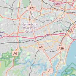
Sefton on the map
Data Sources & Methodology

Our weather forecasts are powered by a professional weather data provider that aggregates data from national weather services, satellite observations, radar networks, and over 80,000 weather stations worldwide. Forecast data is updated multiple times daily. We convert raw data into clear summaries — wind speed in m/s, pressure in mmHg — so you can plan your day with confidence.