
5-day weather forecast Kali Oct 12, 2026
 21°
21°Weather forecast Kali Monday Oct 12, 2026: sunny, temperature from 15 °C to 21 °C.
Precipitation probability 12%. Wind up to 4.69 m/s (gusts 7.19 m/s). Air humidity 38–57%, atmospheric pressure 761–766 mm Hg, UV index up to 2.9.
Weather Alerts
Yellow wind warning
Fresh, locally strong NE wind. Maximum wind gusts 35-45 knots (65-85 km/h)
IMPACT: Although rather usual in this region, locally or potentially dangerous wind speeds are expected to produce dangerous wave conditions to small crafts. Inexperienced mariners, especially those operating smaller vessels, should avoid navigating in these conditions.
Mariners should pay close attention to the marine forecast and consider wind and sea conditions in planning. It is possible that some ferry lines will not operate so follow traffic information if travelling.
Yellow wind warning
Locally fresh NE wind. Maximum wind gusts 35-40 knots (65-75 km/h)
IMPACT: Although rather usual in this region, locally or potentially dangerous wind speeds are expected to produce dangerous wave conditions to small crafts. Inexperienced mariners, especially those operating smaller vessels, should avoid navigating in these conditions.
Mariners should pay close attention to the marine forecast and consider wind and sea conditions in planning. It is possible that some ferry lines will not operate so follow traffic information if travelling.
Yellow wind warning
Fresh, locally strong NE wind. Maximum wind gusts 35-45 knots (65-85 km/h)
IMPACT: Although rather usual in this region, locally or potentially dangerous wind speeds are expected to produce dangerous wave conditions to small crafts. Inexperienced mariners, especially those operating smaller vessels, should avoid navigating in these conditions.
Mariners should pay close attention to the marine forecast and consider wind and sea conditions in planning. It is possible that some ferry lines will not operate so follow traffic information if travelling.
Yellow wind warning
Fresh, locally strong NE wind. Maximum wind gusts 35-45 knots (65-85 km/h)
IMPACT: Although rather usual in this region, locally or potentially dangerous wind speeds are expected to produce dangerous wave conditions to small crafts. Inexperienced mariners, especially those operating smaller vessels, should avoid navigating in these conditions.
Mariners should pay close attention to the marine forecast and consider wind and sea conditions in planning. It is possible that some ferry lines will not operate so follow traffic information if travelling.
Yellow wind warning
Locally fresh NE wind. Maximum wind gusts 35-40 knots (65-75 km/h)
IMPACT: Although rather usual in this region, locally or potentially dangerous wind speeds are expected to produce dangerous wave conditions to small crafts. Inexperienced mariners, especially those operating smaller vessels, should avoid navigating in these conditions.
Mariners should pay close attention to the marine forecast and consider wind and sea conditions in planning. It is possible that some ferry lines will not operate so follow traffic information if travelling.
5 days at a glance — tap a day to open it
Sunrise 07:10
Sunset 18:21
Sunset 18:21
Waxing Crescent5% illuminated
Moonrise 09:18 · Moonset 18:50
Moonrise 09:18 · Moonset 18:50
Chart
TableForecast from 15 °C to 21 °C and precipitation
Cloud cover and precipitation probability
Wind speed and direction
Air humidity
Atmospheric pressure
Ultraviolet index
Air quality & pollen
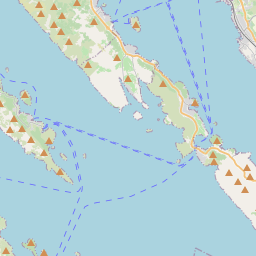
Kali on the map
Data Sources & Methodology
Our weather forecasts are powered by a professional weather data provider that aggregates data from national weather services, satellite observations, radar networks, and over 80,000 weather stations worldwide. Forecast data is updated multiple times daily. We convert raw data into clear summaries — wind speed in m/s, pressure in mmHg — so you can plan your day with confidence.