
5-day weather forecast Seoul Oct 26, 2026
 15°
Weather forecast Seoul today Oct 26, 2026: overcast, temperature from 14 °C to 18 °C.
Precipitation probability 41%. Wind up to 2.81 m/s (gusts 5.72 m/s). Air humidity 58–85%, atmospheric pressure 763–765 mm Hg, UV index up to 2.4.
5 days at a glance — tap a day to open it
Sunrise 06:50
Sunset 17:40
Sunset 17:40
Full Moon98% illuminated
Moonrise 17:19 · Moonset 06:41
Moonrise 17:19 · Moonset 06:41
Chart
Table
Mon, Oct 26, 2026
| Time | Weather | Temperature | Rain chance | Cloud cover | Humidity | Pressure | Wind | UV Index |
|---|---|---|---|---|---|---|---|---|
| 00:00 |  Overcast | 16 °C | 17% | 94% | 70% | 765 mm Hg | NE 55° 2.69 (5.72) m/s | 0 |
| 01:00 | Overcast | 17 °C | 16% | 100% | 64% | 764 mm Hg | ENE 61° 2.81 (5.39) m/s | 0 |
| 02:00 | Overcast | 17 °C | 16% | 100% | 64% | 764 mm Hg | ENE 62° 2.69 (5.31) m/s | 0 |
| 03:00 |  Light drizzle | 15 °C | 41% (0.22 mm/hr) | 100% | 74% | 764 mm Hg | NE 52° 2.5 (4.92) m/s | 0 |
| 04:00 | Overcast | 17 °C | 16% | 100% | 64% | 764 mm Hg | NE 53° 2.5 (4.22) m/s | 0 |
| 05:00 | Overcast | 16 °C | 16% | 100% | 64% | 764 mm Hg | ENE 68° 2.31 (3.89) m/s | 0 |
| 06:00 |  Patchy rain possible | 14 °C | 29% (0.07 mm/hr) | 100% | 79% | 764 mm Hg | ENE 60° 2.39 (4.86) m/s | 0 |
| 07:00 |  Overcast | 16 °C | 15% | 95% | 64% | 764 mm Hg | ENE 77° 2 (3.89) m/s | 0 |
| 08:00 |  Cloudy | 16 °C | 10% | 64% | 64% | 764 mm Hg | ENE 73° 1.5 (2.42) m/s | 0.1 |
| 09:00 | Patchy rain possible | 15 °C | 30% (0.12 mm/hr) | 99% | 75% | 764 mm Hg | ENE 61° 1.61 (3.58) m/s | 0.5 |
| 10:00 | Overcast | 17 °C | 14% | 100% | 59% | 764 mm Hg | NNE 24° 1.89 (2.19) m/s | 0.8 |
| 11:00 | Cloudy | 18 °C | 10% | 76% | 58% | 764 mm Hg | N 355° 2.19 (2.69) m/s | 1.1 |
| 12:00 | Patchy rain possible | 17 °C | 19% (0.02 mm/hr) | 99% | 69% | 764 mm Hg | N 357° 1.69 (3.44) m/s | 2.4 |
| 13:00 | Patchy rain possible | 18 °C | 16% (0.03 mm/hr) | 100% | 60% | 764 mm Hg | N 355° 1.89 (2.11) m/s | 1.1 |
| 14:00 | Overcast | 18 °C | 16% | 100% | 63% | 764 mm Hg | N 1° 2 (2.19) m/s | 0.8 |
| 15:00 | Patchy rain possible | 17 °C | 22% (0.04 mm/hr) | 99% | 72% | 763 mm Hg | N 350° 1.39 (3.61) m/s | 0.7 |
| 16:00 |  Partly cloudy | 17 °C | 10% | 57% | 67% | 763 mm Hg | N 2° 1.31 (1.5) m/s | 0.5 |
| 17:00 | Overcast | 17 °C | 16% | 90% | 68% | 764 mm Hg | NNW 332° 1.69 (2.92) m/s | 0.2 |
| 18:00 |  Clear | 15 °C | 11% | 25% | 80% | 763 mm Hg | NW 314° 1.11 (2.17) m/s | 0 |
| 19:00 | Clear | 17 °C | 6% | 0% | 70% | 764 mm Hg | NW 325° 0.81 (1.22) m/s | 0 |
| 20:00 | Clear | 16 °C | 6% | 6% | 71% | 764 mm Hg | WNW 285° 0.5 (0.81) m/s | 0 |
| 21:00 | Clear | 14 °C | 12% | 10% | 85% | 764 mm Hg | W 266° 1 (1.94) m/s | 0 |
| 22:00 | Clear | 16 °C | 7% | 22% | 70% | 764 mm Hg | W 268° 1 (1.61) m/s | 0 |
| 23:00 | Overcast | 16 °C | 18% | 95% | 71% | 764 mm Hg | WNW 287° 0.89 (2.31) m/s | 0 |
Mon, Oct 26, 2026
Frequently asked questions about the 5-day weather in Seoul
What will the weather be like in Seoul over the next 5 days?
Over the next 5 days in Seoul the temperature is expected to range from about 3 to 18 °C. See the detailed hourly forecast for each of the 5 days in the charts above.
On which of the next 5 days will it rain in Seoul?
The chance of rain in Seoul over the next 5 days reaches 59%. Check the 5-day precipitation chart above to see exactly which days and hours bring rain.
How accurate is the 5-day weather forecast for Seoul?
A 5-day forecast is fairly reliable: the first 2–3 days are usually very accurate, while days 4–5 may be refined. The data is updated several times a day, so check back before important plans.
Which of the next 5 days in Seoul will be the warmest and which the coolest?
Over the next 5 days the temperature in Seoul ranges from about 3 to 18 °C. Compare the warmest and coolest day on the temperature chart above.
Will it be windy in Seoul over the next 5 days?
Over the next 5 days the wind in Seoul picks up to 9 m/s. The windiest days are easy to spot on the wind chart above.
Which day of the week in Seoul is best for a walk or a trip?
For a walk or a trip, pick the days with the lowest chance of rain (up to 59%) and light wind — easy to compare on the 5-day charts above.
How can I best use the 5-day forecast for Seoul?
The first 2–3 days are reliable enough for firm decisions, while days 4–5 are a guide that sharpens as they approach. The forecast is updated several times a day, so check again before important plans.
Will I need an umbrella or sunscreen in Seoul this week?
Rain reaches a 59% chance across the next 5 days, so pack something waterproof for the wettest of them — the daily strip above shows which. Today’s UV index peaks at 2.4; sunscreen is worth it from about 3 upwards.
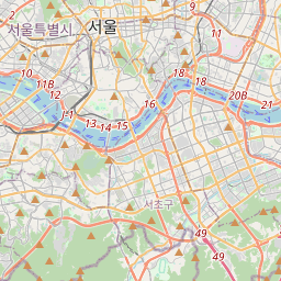
Seoul on the map
Data Sources & Methodology
Our weather forecasts are powered by a professional weather data provider that aggregates data from national weather services, satellite observations, radar networks, and over 80,000 weather stations worldwide. Forecast data is updated multiple times daily. We convert raw data into clear summaries — wind speed in m/s, pressure in mmHg — so you can plan your day with confidence.