
5-day weather forecast Iisalmi Nov 12, 2026
 1°
Weather forecast Iisalmi tomorrow Nov 12, 2026: moderate snow, temperature from -1 °C to 1 °C.
Precipitation probability 58%. Wind up to 4.81 m/s (gusts 9.86 m/s). Air humidity 89–94%, atmospheric pressure 749–752 mm Hg, UV index up to 0.1.
Weather Alerts
Yellow traffic weather warning: Locally in the middle part of the country, Wed 0.00 - Thu 0.00
Traffic weather warning
Traffic weather warning: Bad road conditions are expected at first because of snow or sleet.
Yellow traffic weather warning: The middle and locally in northern parts of the country, Sat 0.00 - Sun 0.00
Traffic weather warning
Traffic weather warning: From the night between Friday and Saturday to the night between Saturday and Sunday, probability for bad road conditions is 30% because of snow or sleet.
Yellow traffic weather warning: Locally in the middle and northern parts of the country, Thu 0.00 - Fri 0.00
Traffic weather warning
Traffic weather warning: From the night between Wednesday and Thursday to the night between Thursday and Friday, probability for bad road conditions is 40% because of snow or sleet.
Yellow traffic weather warning: Locally in over the whole country, Fri 0.00 - Sat 0.00
Traffic weather warning
Traffic weather warning: From the night between Thursday and Friday to the night between Friday and Saturday, probability for bad road conditions is 60% because of snow or sleet.
Yellow traffic weather warning: Locally in the middle part of the country, Wed 0.09 - Thu 0.00
Traffic weather warning
Traffic weather warning: Bad road conditions are expected at first because of snow or sleet.
5 days at a glance — tap a day to open it
Sunrise 08:25
Sunset 15:24
Sunset 15:24
Waxing Crescent14% illuminated
Moonrise does not rise today · Moonset does not set today
Moonrise does not rise today · Moonset does not set today
Chart
Table
| Time | Weather | Temperature | Rain chance | Cloud cover | Humidity | Pressure | Wind | UV Index |
|---|---|---|---|---|---|---|---|---|
| 00:00 |  Moderate snow | -1 °C | 44% (0.13 mm/hr) | 100% | 90% | 752 mm Hg | ENE 63° 2.39 (5.33) m/s | 0 |
| 01:00 | Moderate snow | 0 °C | 49% (0.2 mm/hr) | 100% | 91% | 752 mm Hg | ENE 65° 2.39 (5.47) m/s | 0 |
| 02:00 |  Heavy snow | 0 °C | 56% (0.26 mm/hr) | 100% | 91% | 752 mm Hg | ENE 68° 2.5 (5.69) m/s | 0 |
| 03:00 | Heavy snow | 0 °C | 58% (0.29 mm/hr) | 100% | 92% | 752 mm Hg | ENE 71° 2.61 (5.97) m/s | 0 |
| 04:00 | Moderate snow | 0 °C | 52% (0.25 mm/hr) | 100% | 92% | 751 mm Hg | ENE 76° 2.69 (6.17) m/s | 0 |
| 05:00 | Moderate snow | 0 °C | 47% (0.16 mm/hr) | 100% | 92% | 751 mm Hg | ENE 78° 2.69 (6.08) m/s | 0 |
| 06:00 | Moderate snow | 0 °C | 49% (0.18 mm/hr) | 100% | 93% | 751 mm Hg | E 80° 2.69 (6.14) m/s | 0 |
| 07:00 | Moderate snow | 0 °C | 48% (0.16 mm/hr) | 100% | 93% | 751 mm Hg | E 84° 2.69 (6.11) m/s | 0 |
| 08:00 | Moderate snow | 0 °C | 44% (0.1 mm/hr) | 100% | 93% | 751 mm Hg | E 88° 2.69 (5.92) m/s | 0 |
| 09:00 | Moderate snow | 0 °C | 43% (0.08 mm/hr) | 100% | 93% | 751 mm Hg | E 89° 2.5 (5.69) m/s | 0 |
| 10:00 |  Light snow | 1 °C | 37% (0.05 mm/hr) | 100% | 93% | 751 mm Hg | E 90° 2.39 (5.56) m/s | 0 |
| 11:00 | Light snow | 1 °C | 34% (0.02 mm/hr) | 100% | 93% | 751 mm Hg | E 93° 2.31 (5.67) m/s | 0 |
| 12:00 | Light snow | 1 °C | 33% (0.02 mm/hr) | 97% | 92% | 750 mm Hg | ESE 104° 2.5 (5.92) m/s | 0 |
| 13:00 |  Patchy rain possible | 1 °C | 31% (0.01 mm/hr) | 95% | 91% | 750 mm Hg | ESE 111° 2.81 (6.22) m/s | 0.1 |
| 14:00 |  Overcast | 1 °C | 28% | 91% | 89% | 750 mm Hg | ESE 112° 3.11 (6.44) m/s | 0.1 |
| 15:00 | Overcast | 1 °C | 28% | 91% | 90% | 750 mm Hg | ESE 108° 3.31 (6.83) m/s | 0 |
| 16:00 |  Overcast | 1 °C | 30% | 95% | 91% | 750 mm Hg | ESE 106° 3.39 (7.17) m/s | 0 |
| 17:00 |  Light freezing rain | 1 °C | 33% (0.01 mm/hr) | 100% | 94% | 750 mm Hg | E 100° 3.5 (7.53) m/s | 0 |
| 18:00 |  Light snow | 1 °C | 34% (0.02 mm/hr) | 100% | 94% | 749 mm Hg | E 98° 3.89 (8.22) m/s | 0 |
| 19:00 | Light snow | 1 °C | 35% (0.03 mm/hr) | 100% | 94% | 749 mm Hg | E 100° 4.19 (8.83) m/s | 0 |
| 20:00 | Light snow | 1 °C | 36% (0.04 mm/hr) | 100% | 94% | 749 mm Hg | E 101° 4.39 (9.28) m/s | 0 |
| 21:00 | Moderate snow | 1 °C | 46% (0.12 mm/hr) | 100% | 93% | 749 mm Hg | ESE 102° 4.5 (9.64) m/s | 0 |
| 22:00 | Moderate snow | 1 °C | 50% (0.19 mm/hr) | 100% | 94% | 749 mm Hg | ESE 103° 4.61 (9.83) m/s | 0 |
| 23:00 | Heavy snow | 1 °C | 57% (0.27 mm/hr) | 100% | 93% | 749 mm Hg | ESE 104° 4.81 (9.86) m/s | 0 |
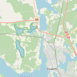
Iisalmi on the map
Data Sources & Methodology
Our weather forecasts are powered by a professional weather data provider that aggregates data from national weather services, satellite observations, radar networks, and over 80,000 weather stations worldwide. Forecast data is updated multiple times daily. We convert raw data into clear summaries — wind speed in m/s, pressure in mmHg — so you can plan your day with confidence.