
5-day weather forecast Auerbach Oct 22, 2026
 10°
10°Weather forecast Auerbach tomorrow Oct 22, 2026: sunny, temperature from 5 °C to 10 °C.
Precipitation probability 78%. Wind up to 6.19 m/s (gusts 12.53 m/s). Air humidity 58–96%, atmospheric pressure 761–766 mm Hg, UV index up to 1.1.
Weather Alerts
Moderate Wind Related Impact
SE wind with gusts between 15 and 20 m/s (55 to 70 km/h).
Possible complications in the energy industry, forestry, and transport. Possible damage to trees and forests. Minor damage to energy infrastructure, property (especially older buildings). Risk of injury from flying or falling objects, especially broken branches. Minor travel delays due to debris and outages.
Secure windows, doors, remove or anchor loosely stored objects, tents, greenhouses, etc. Watch out for falling objects such as branches or roof tiles. When driving, watch out for strong crosswinds at exposed points such as bridges, drive slowly. In the mountains, limit hikes and avoid ridge areas in particular.
Moderate Wind Related Impact
SE wind with gusts between 15 and 20 m/s (55 to 70 km/h).
Possible complications in the energy industry, forestry, and transport. Possible damage to trees and forests. Minor damage to energy infrastructure, property (especially older buildings). Risk of injury from flying or falling objects, especially broken branches. Minor travel delays due to debris and outages.
Secure windows, doors, remove or anchor loosely stored objects, tents, greenhouses, etc. Watch out for falling objects such as branches or roof tiles. When driving, watch out for strong crosswinds at exposed points such as bridges, drive slowly. In the mountains, limit hikes and avoid ridge areas in particular.
Moderate Wind Related Impact
SE wind with gusts between 15 and 20 m/s (55 to 70 km/h).
Possible complications in the energy industry, forestry, and transport. Possible damage to trees and forests. Minor damage to energy infrastructure, property (especially older buildings). Risk of injury from flying or falling objects, especially broken branches. Minor travel delays due to debris and outages.
Secure windows, doors, remove or anchor loosely stored objects, tents, greenhouses, etc. Watch out for falling objects such as branches or roof tiles. When driving, watch out for strong crosswinds at exposed points such as bridges, drive slowly. In the mountains, limit hikes and avoid ridge areas in particular.
Moderate Wind Related Impact
SE wind with gusts between 15 and 20 m/s (55 to 70 km/h).
Possible complications in the energy industry, forestry, and transport. Possible damage to trees and forests. Minor damage to energy infrastructure, property (especially older buildings). Risk of injury from flying or falling objects, especially broken branches. Minor travel delays due to debris and outages.
Secure windows, doors, remove or anchor loosely stored objects, tents, greenhouses, etc. Watch out for falling objects such as branches or roof tiles. When driving, watch out for strong crosswinds at exposed points such as bridges, drive slowly. In the mountains, limit hikes and avoid ridge areas in particular.
5 days at a glance — tap a day to open it
Sunrise 07:44
Sunset 18:04
Sunset 18:04
Waxing Gibbous92% illuminated
Moonrise 16:34 · Moonset 03:20
Moonrise 16:34 · Moonset 03:20
Chart
Table
| Time | Weather | Temperature | Rain chance | Cloud cover | Humidity | Pressure | Wind | UV Index |
|---|---|---|---|---|---|---|---|---|
| 00:00 |  Light rain | 7 °C | 78% (1.16 mm/hr) | 100% | 95% | 761 mm Hg | WSW 241° 4.89 (10.61) m/s | 0 |
| 01:00 |  Light drizzle | 7 °C | 52% (0.16 mm/hr) | 100% | 94% | 761 mm Hg | WSW 246° 5.39 (10.81) m/s | 0 |
| 02:00 |  Light rain shower | 7 °C | 47% (0.16 mm/hr) | 100% | 96% | 761 mm Hg | WSW 246° 5.39 (10.03) m/s | 0 |
| 03:00 |  Patchy rain possible | 6 °C | 31% (0.01 mm/hr) | 100% | 90% | 762 mm Hg | WSW 252° 5.61 (11.39) m/s | 0 |
| 04:00 | Patchy rain possible | 6 °C | 33% (0.02 mm/hr) | 100% | 91% | 763 mm Hg | WSW 248° 5.61 (11.19) m/s | 0 |
| 05:00 | Patchy rain possible | 5 °C | 31% (0.01 mm/hr) | 100% | 90% | 764 mm Hg | WSW 247° 5.69 (11.31) m/s | 0 |
| 06:00 |  Overcast | 5 °C | 30% | 100% | 90% | 764 mm Hg | WSW 245° 5.31 (11) m/s | 0 |
| 07:00 |  Cloudy | 5 °C | 25% | 83% | 88% | 764 mm Hg | WSW 238° 5.19 (10.72) m/s | 0 |
| 08:00 |  Cloudy | 5 °C | 20% | 67% | 86% | 765 mm Hg | SW 234° 5.61 (11.31) m/s | 0 |
| 09:00 |  Partly cloudy | 5 °C | 15% | 34% | 86% | 765 mm Hg | SW 226° 5.61 (12.11) m/s | 0.1 |
| 10:00 | Partly cloudy | 5 °C | 19% | 59% | 85% | 765 mm Hg | SW 231° 5.81 (12.5) m/s | 0.3 |
| 11:00 | Partly cloudy | 6 °C | 16% | 57% | 81% | 766 mm Hg | SW 233° 6 (12.53) m/s | 0.7 |
| 12:00 | Sunny | 7 °C | 9% | 19% | 75% | 765 mm Hg | SW 232° 5.89 (11.53) m/s | 0.9 |
| 13:00 | Sunny | 9 °C | 5% | 5% | 65% | 764 mm Hg | SW 235° 6.19 (10.42) m/s | 1.1 |
| 14:00 | Sunny | 10 °C | 4% | 5% | 59% | 764 mm Hg | SW 236° 6.11 (9.64) m/s | 1.1 |
| 15:00 | Sunny | 10 °C | 3% | 4% | 58% | 764 mm Hg | SW 236° 5.81 (9.92) m/s | 0.5 |
| 16:00 | Sunny | 10 °C | 4% | 1% | 61% | 764 mm Hg | SW 235° 5.39 (9.89) m/s | 0.3 |
| 17:00 | Sunny | 9 °C | 5% | 4% | 66% | 764 mm Hg | SW 235° 5.11 (10.22) m/s | 0 |
| 18:00 | Partly cloudy | 7 °C | 9% | 30% | 73% | 765 mm Hg | SW 224° 4.19 (10.11) m/s | 0 |
| 19:00 | Overcast | 6 °C | 23% | 100% | 78% | 766 mm Hg | SSW 205° 3.61 (10.42) m/s | 0 |
| 20:00 | Overcast | 8 °C | 21% | 100% | 74% | 766 mm Hg | SSW 213° 4.31 (10.61) m/s | 0 |
| 21:00 | Overcast | 8 °C | 22% | 100% | 76% | 766 mm Hg | SSW 213° 4.31 (10.83) m/s | 0 |
| 22:00 | Patchy rain possible | 8 °C | 22% (0.01 mm/hr) | 100% | 76% | 766 mm Hg | SW 216° 4.19 (10.72) m/s | 0 |
| 23:00 | Overcast | 8 °C | 20% | 95% | 75% | 766 mm Hg | SSW 210° 3.81 (10.33) m/s | 0 |
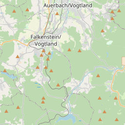
Auerbach on the map
Data Sources & Methodology
Our weather forecasts are powered by a professional weather data provider that aggregates data from national weather services, satellite observations, radar networks, and over 80,000 weather stations worldwide. Forecast data is updated multiple times daily. We convert raw data into clear summaries — wind speed in m/s, pressure in mmHg — so you can plan your day with confidence.