
Orų prognozė 5 dienoms Kali 2026-11-23
 12°
Orų prognozė — Kali, pirmadienis, 2026-11-23: mažai debesuota, temperatūra nuo 6 °C iki 12 °C.
Kritulių tikimybė 74%. Vėjas iki 8.61 m/s (gūsiai 14.33 m/s). Oro drėgmė 53–84%, atmosferos slėgis 752–766 mm Hg, UV indeksas iki 1.4.
Oro perspėjimai
Yellow wind warning
SE wind increasing to strong or near gale force, veering to southwesterly by the end of the day. Maximum wind gusts 35-40 knots (65-75 km/h)
IMPACT: Although rather usual in this region, locally or potentially dangerous wind speeds are expected to produce dangerous wave conditions to small crafts. Inexperienced mariners, especially those operating smaller vessels, should avoid navigating in these conditions.
Mariners should pay close attention to the marine forecast and consider wind and sea conditions in planning. It is possible that some ferry lines will not operate so follow traffic information if travelling.
Yellow wind warning
SE wind increasing to strong or near gale force, veering to southwesterly by the end of the day. Maximum wind gusts 35-40 knots (65-75 km/h)
IMPACT: Although rather usual in this region, locally or potentially dangerous wind speeds are expected to produce dangerous wave conditions to small crafts. Inexperienced mariners, especially those operating smaller vessels, should avoid navigating in these conditions.
Mariners should pay close attention to the marine forecast and consider wind and sea conditions in planning. It is possible that some ferry lines will not operate so follow traffic information if travelling.
Yellow wind warning
SE wind increasing to strong or near gale force, veering to southwesterly and northwesterly by the end of the day. Maximum wind gusts 35-40 knots (65-75 km/h)
IMPACT: Although rather usual in this region, locally or potentially dangerous wind speeds are expected to produce dangerous wave conditions to small crafts. Inexperienced mariners, especially those operating smaller vessels, should avoid navigating in these conditions.
Mariners should pay close attention to the marine forecast and consider wind and sea conditions in planning. It is possible that some ferry lines will not operate so follow traffic information if travelling.
Yellow wind warning
SE wind increasing to strong or near gale force, veering to southwesterly and northwesterly by the end of the day. Maximum wind gusts 35-40 knots (65-75 km/h)
IMPACT: Although rather usual in this region, locally or potentially dangerous wind speeds are expected to produce dangerous wave conditions to small crafts. Inexperienced mariners, especially those operating smaller vessels, should avoid navigating in these conditions.
Mariners should pay close attention to the marine forecast and consider wind and sea conditions in planning. It is possible that some ferry lines will not operate so follow traffic information if travelling.
Yellow wind warning
SE wind increasing to strong or near gale force, veering to southwesterly and northwesterly by the end of the day. Maximum wind gusts 35-40 knots (65-75 km/h)
IMPACT: Although rather usual in this region, locally or potentially dangerous wind speeds are expected to produce dangerous wave conditions to small crafts. Inexperienced mariners, especially those operating smaller vessels, should avoid navigating in these conditions.
Mariners should pay close attention to the marine forecast and consider wind and sea conditions in planning. It is possible that some ferry lines will not operate so follow traffic information if travelling.
5 dienų glaustai — spustelėkite dieną, kad ją atidarytumėte
Saulėtekis 07:04
Saulėlydis 16:26
Saulėlydis 16:26
Pilnatis100% apšvietimo
Mėnulio patekėjimas 15:08 · Mėnulio nusileidimas 05:37
Mėnulio patekėjimas 15:08 · Mėnulio nusileidimas 05:37
Diagrama
LentelėPrognozė nuo 6 °C iki 12 °C ir krituliai
Debesuotumas ir kritulių tikimybė
Vėjo greitis ir kryptis
Oro drėgmė
Atmosferos slėgis
Ultravioletinis indeksas
Oro kokybė ir žiedadulkės
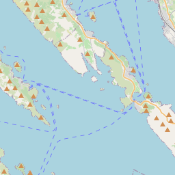
Kali žemėlapyje
Duomenų šaltiniai ir metodologija
Mūsų orų prognozės yra paremtos profesionaliu orų duomenų tiekėju, kuris apibendrina duomenis iš nacionalinių meteorologijos tarnybų, palydovinių stebėjimų, radarų tinklų ir daugiau nei 80 000 meteorologinių stočių visame pasaulyje. Prognozių duomenys atnaujinami kelis kartus per dieną. Neapdorotus duomenis paverčiame aiškiomis santraukomis – vėjo greitis m/s, slėgis mm Hg – kad galėtumėte planuoti savo dieną su pasitikėjimu.