
5-Tage-Wettervorhersage Salinas 20. Nov. 2026

15°7° · Sonnig

Wettervorhersage Salinas Freitag 20. Nov. 2026: sonnig, Temperatur von 7 °C bis 15 °C.

Niederschlagswahrscheinlichkeit 34%. Wind bis zu 2.19 m/s (Böen 4.83 m/s). Luftfeuchtigkeit 58–91%, Luftdruck 764–765 mm Hg, UV-Index bis 2.8.

Wetterwarnungen

Severe17. Nov., 11:48 — 18. Nov., 05:15Mit Google übersetzen
Flash Flood Watch issued November 17 at 11:48AM PST until November 19 at 4:00AM PST by NWS San Francisco CA

Flash Flood Watch

* WHAT...Flash flooding and debris flows caused by excessive rainfall are possible over the Plaskett and Timber burn areas. * WHERE...For the Timber Scar, portions of CA Highway 1 and the Los Padres National Forecast from Andrew Molera State Park to Partington Ridge including the town of Big Sur. For the Plaskett Scar, areas near CA Highway 1 mile marker 17 to mile marker 11 including Los Burros Road. * WHEN...From early Wednesday morning to early Thursday morning. * IMPACTS...Heavy rainfall over the Timber and Plaskett burn areas is expected during the watch period. Residents near the Timber burn area should prepare for potential debris flow moving through the drainages within Lafler, Castro, and Graves Canyons, as well as drainages between Grimes and Castro Canyons. Residents near the Plaskett burn area should prepare for potential debris flow moving through the Alder, Plaskett, and Prewitt Creeks. Be sure to stay up to date with information from local authorities. Heavy rainfall could trigger flash flooding of low-lying areas, roadway flooding, and debris flows in and near recent wildfire burn scars. * ADDITIONAL DETAILS... - National Weather Service Meteorologists are forecasting heavy rainfall over the Timber and Plaskett burn areas, which may lead to flash flooding and debris flows. - Some locations that may experience flash flooding include... Big Sur, Plaskett, and Pfeiffer Big Sur State Park - http://www.weather.gov/safety/flood
Minor17. Nov., 14:29 — 17. Nov., 22:30Mit Google übersetzen
Small Craft Advisory issued November 17 at 2:29PM PST until November 18 at 3:00AM PST by NWS San Francisco CA

Small Craft Advisory

* WHAT...For the Small Craft Advisory, south winds 10 to 20 kt with gusts up to 30 kt expected. For the Gale Warning, south winds 20 to 30 kt with gusts up to 45 kt expected. * WHERE...Monterey Bay. * WHEN...For the Small Craft Advisory, from 9 PM this evening to 3 AM PST Wednesday. For the Gale Warning, from 3 AM to 3 PM PST Wednesday. * IMPACTS...Strong winds will cause hazardous seas which could capsize or damage vessels and reduce visibility.
Moderate17. Nov., 14:29 — 17. Nov., 22:30Mit Google übersetzen
Gale Warning issued November 17 at 2:29PM PST until November 18 at 3:00PM PST by NWS San Francisco CA

Gale Warning

* WHAT...For the Small Craft Advisory, south winds 10 to 20 kt with gusts up to 30 kt expected. For the Gale Warning, south winds 20 to 30 kt with gusts up to 45 kt expected. * WHERE...Monterey Bay. * WHEN...For the Small Craft Advisory, from 9 PM this evening to 3 AM PST Wednesday. For the Gale Warning, from 3 AM to 3 PM PST Wednesday. * IMPACTS...Strong winds will cause hazardous seas which could capsize or damage vessels and reduce visibility.
5 Tage im Überblick — tippen Sie auf einen Tag, um ihn zu öffnen
Sonnenaufgang 06:49
Sonnenuntergang 16:54
Zunehmender Mond89% beleuchtet
Mondaufgang 14:19 · Monduntergang 02:36
Diagramm
Tabelle

Vorhersage von 7 °C bis 15 °C und Niederschlag

Temperatur & Niederschlag
Uhrzeit00:0001:0002:0003:0004:0005:0006:0007:0008:0009:0010:0011:0012:0013:0014:0015:0016:0017:0018:0019:0020:0021:0022:0023:00
Temperatur (°C)1010998887911131415151515141211109877
Niederschlag (mm/Std.)0.180.120.040.030.020.010000000.010.010.01000000000

Bewölkung und Niederschlagswahrscheinlichkeit

Bewölkung & Regenwahrscheinlichkeit
Uhrzeit00:0001:0002:0003:0004:0005:0006:0007:0008:0009:0010:0011:0012:0013:0014:0015:0016:0017:0018:0019:0020:0021:0022:0023:00
Bewölkung (%)508182817384201423383810787375121184001119
Regenwahrscheinlichkeit (%)333428282528161513121061210104467910101113

Windgeschwindigkeit und -richtung

Wind & Windböe
Uhrzeit00:0001:0002:0003:0004:0005:0006:0007:0008:0009:0010:0011:0012:0013:0014:0015:0016:0017:0018:0019:0020:0021:0022:0023:00
Wind (m/s)0.690.810.811.311.691.691.811.691.3910.690.691.312.112.192.19210.51.611.891.891.891.89
Windböe (m/s)4.834.694.173.673.753.472.892.442.672.812.753.033.924.724.724.394.644.113.313.083.253.283.252.22
Windrichtung (°)SSW 212°S 183°SO 125°OSO 111°OSO 108°OSO 105°O 101°O 97°O 98°O 95°ONO 77°N 357°NW 311°WNW 302°WNW 290°W 276°W 263°W 260°SO 125°O 98°O 96°O 96°O 98°O 91°

Luftfeuchtigkeit

Feuchtigkeit
Uhrzeit00:0001:0002:0003:0004:0005:0006:0007:0008:0009:0010:0011:0012:0013:0014:0015:0016:0017:0018:0019:0020:0021:0022:0023:00
Feuchtigkeit (%)888788899091919085787468625859606268727880838485

Luftdruck

Druck
Uhrzeit00:0001:0002:0003:0004:0005:0006:0007:0008:0009:0010:0011:0012:0013:0014:0015:0016:0017:0018:0019:0020:0021:0022:0023:00
Druck (mm Hg)764764764764764764764764765765765765764764764764764764764764764764764764

Ultraviolett-Index

UV-Index
Uhrzeit00:0001:0002:0003:0004:0005:0006:0007:0008:0009:0010:0011:0012:0013:0014:0015:0016:0017:0018:0019:0020:0021:0022:0023:00
UV-Index000000000.20.71.62.42.82.61.910.30000000

Luftqualität & Pollen

Luftqualitätsdaten sind nur für die ersten drei Tage verfügbar.

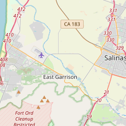
Salinas auf der Karte
Datenquellen & Methodik

Unsere Wettervorhersagen werden von einem professionellen Wetterdatenanbieter bereitgestellt, der Daten von nationalen Wetterdiensten, Satellitenbeobachtungen, Radarnetzwerken und über 80.000 Wetterstationen weltweit zusammenführt. Die Vorhersagedaten werden mehrmals täglich aktualisiert. Wir wandeln Rohdaten in übersichtliche Zusammenfassungen um – Windgeschwindigkeit in m/s, Luftdruck in mmHg – damit Sie Ihren Tag mit Zuversicht planen können.