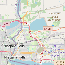
5-Tage-Wettervorhersage Niagara Falls 31-07-2026
Wettervorhersage Niagara Falls Freitag, 31. Juli 31.07.2026: sonnig, Temperatur von 19 °C bis 27 °C.
Niederschlagswahrscheinlichkeit 13%. Wind bis zu 2.31 m/s (Böen 4.58 m/s). Luftfeuchtigkeit 51–87%, Luftdruck 759–761 mm Hg, UV-Index bis 8.3.
Wetterwarnungen
Warnungen ausblendenBeach Hazards Statement issued July 28 at 4:04AM EDT until July 29 at 8:00PM EDT by NWS Buffalo NY
Beach Hazards Statement
* WHAT...Strong currents and dangerous swimming conditions
expected.
* WHERE...Beaches of Niagara and Orleans Counties.
* WHEN...From this evening through Wednesday evening.
* IMPACTS...Strong currents and dangerous swimming conditions.
Stay out of the water to avoid dangerous swimming conditions.
Flash Flood Warning issued July 28 at 2:26AM EDT until July 28 at 6:30AM EDT by NWS Buffalo NY
Flash Flood Warning
FFWBUF
The National Weather Service in Buffalo has issued a
* Flash Flood Warning for...
Central Niagara County in western New York...
* Until 630 AM EDT.
* At 226 AM EDT, Doppler radar indicated thunderstorms producing
heavy rain across the warned area. Between 1 and 3 inches of rain
have fallen. Additional rainfall amounts of 1 to 2 inches are
possible in the warned area. Flash flooding is ongoing or expected
to begin shortly.
HAZARD...Flash flooding caused by thunderstorms.
SOURCE...Radar.
IMPACT...Flash flooding of small creeks and streams, urban
areas, highways, streets and underpasses as well as
other poor drainage and low-lying areas.
* Some locations that will experience flash flooding include...
Lockport, Lewiston, Sanborn, Cambria Center, Ransomville and Model
City.
Turn around, don't drown when encountering flooded roads. Most flood
deaths occur in vehicles.
Be especially cautious at night when it is harder to recognize the
dangers of flooding.
Flooding is occurring or is imminent. It is important to know where
you are relative to streams, rivers, or creeks which can become
killers in heavy rains. Campers and hikers should avoid streams or
creeks.
yellow warning - rainfall - in effect
rainfall
Heavy rain is expected.
What:
Heavy rainfall with amounts of 50 to 100 mm
When:
Ending before dawn this morning.
Additional information:
Thunderstorms will continue to move through the area bringing heavy rainfall.
###
Water will likely pool on roads and in low-lying areas.
For information concerning flooding, please consult your local Conservation Authority or Ontario Ministry of Natural Resources office. Visit https://www.ontario.ca/page/floods for the latest details.
Please continue to monitor alerts and forecasts issued by Environment Canada. To report severe weather, send an email to ONstorm@ec.gc.ca or post reports on social media using #ONStorm.
Avoid low-lying areas.
yellow warning - rainfall - in effect
rainfall
Heavy rain is expected.
What:
Heavy rainfall with amounts of 50 to 100 mm
When:
Ending early this morning.
Additional information:
Thunderstorms will continue to move through the area bringing heavy rainfall.
###
Water will likely pool on roads and in low-lying areas.
For information concerning flooding, please consult your local Conservation Authority or Ontario Ministry of Natural Resources office. Visit https://www.ontario.ca/page/floods for the latest details.
Please continue to monitor alerts and forecasts issued by Environment Canada. To report severe weather, send an email to ONstorm@ec.gc.ca or post reports on social media using #ONStorm.
Avoid low-lying areas.
5 Tage im Überblick — tippen Sie auf einen Tag, um ihn zu öffnen
Sonnenaufgang 06:05
Sonnenuntergang 20:39
Abnehmender Mond91% beleuchtet
Mondaufgang 21:46 · Monduntergang 08:15
Diagramm
TabelleVorhersage von 19 °C bis 27 °C und Niederschlag
Bewölkung und Niederschlagswahrscheinlichkeit
Windgeschwindigkeit und -richtung
Luftfeuchtigkeit
Luftdruck
Ultraviolett-Index
Niagara Falls auf der Karte
Datenquellen & Methodik
Unsere Wettervorhersagen werden von einem professionellen Wetterdatenanbieter bereitgestellt, der Daten von nationalen Wetterdiensten, Satellitenbeobachtungen, Radarnetzwerken und über 80.000 Wetterstationen weltweit zusammenführt. Die Vorhersagedaten werden mehrmals täglich aktualisiert. Wir wandeln Rohdaten in übersichtliche Zusammenfassungen um – Windgeschwindigkeit in m/s, Luftdruck in mmHg – damit Sie Ihren Tag mit Zuversicht planen können.