
5-Tage-Wettervorhersage Los Angeles 8. Okt. 2026

33°26° · Sonnig

Wettervorhersage Los Angeles Donnerstag 8. Okt. 2026: sonnig, Temperatur von 26 °C bis 33 °C.

Niederschlagswahrscheinlichkeit 3%. Wind bis zu 5.11 m/s (Böen 10 m/s). Luftfeuchtigkeit 28–56%, Luftdruck 756–758 mm Hg, UV-Index bis 7.2.

Wetterwarnungen

Severe4. Okt., 21:10 — 5. Okt., 06:15Mit Google übersetzen
Extreme Heat Warning issued October 4 at 9:10PM PDT until October 8 at 8:00PM PDT by NWS San Diego CA

Extreme Heat Warning

* WHAT...Dangerously hot conditions with high temperatures ranging from the mid 80s to mid 90s at the beaches to the upper 90s for the inland coastal areas and warm nights with lows in the 70s. * WHERE...Orange County Coastal Areas. * WHEN...Until 8 PM PDT Thursday. * IMPACTS...Heat related illnesses increase significantly during extreme heat events.
Drink plenty of fluids, stay in an air-conditioned room, stay out of the sun, and check up on relatives and neighbors. Do not leave young children and pets in unattended vehicles. Car interiors will reach lethal temperatures in a matter of minutes.
Severe4. Okt., 21:10 — 5. Okt., 06:15Mit Google übersetzen
Extreme Heat Warning issued October 4 at 9:10PM PDT until October 8 at 8:00PM PDT by NWS San Diego CA

Extreme Heat Warning

* WHAT...Dangerously hot conditions with high temperatures 90 to 100 and warm nights with lows in the low to mid 70s. * WHERE...Santa Ana Mountains and Foothills. * WHEN...Until 8 PM PDT Thursday. * IMPACTS...Heat related illnesses increase significantly during extreme heat events.
Drink plenty of fluids, stay in an air-conditioned room, stay out of the sun, and check up on relatives and neighbors. Do not leave young children and pets in unattended vehicles. Car interiors will reach lethal temperatures in a matter of minutes.
Severe4. Okt., 21:10 — 5. Okt., 06:15Mit Google übersetzen
Extreme Heat Warning issued October 4 at 9:10PM PDT until October 8 at 8:00PM PDT by NWS San Diego CA

Extreme Heat Warning

* WHAT...Dangerously hot conditions with high temperatures in the mid 90s to 103 and warm nights with low temperatures in the 70s. * WHERE...Orange County Inland Areas. * WHEN...Until 8 PM PDT Thursday. * IMPACTS...Heat related illnesses increase significantly during extreme heat events.
Drink plenty of fluids, stay in an air-conditioned room, stay out of the sun, and check up on relatives and neighbors. Do not leave young children and pets in unattended vehicles. Car interiors will reach lethal temperatures in a matter of minutes.
Severe5. Okt., 03:19 — 5. Okt., 15:45Mit Google übersetzen
Extreme Heat Warning issued October 5 at 3:19AM PDT until October 8 at 8:00PM PDT by NWS San Diego CA

Extreme Heat Warning

* WHAT...Dangerously hot conditions with high temperatures in the upper 90s to 103. Nights will be very warm with low temperatures in the lower to mid 70s. * WHERE...Orange County Inland Areas. * WHEN...Until 8 PM PDT Thursday. * IMPACTS...Heat related illnesses increase significantly during extreme heat events.
Drink plenty of fluids, stay in an air-conditioned room, stay out of the sun, and check up on relatives and neighbors. Do not leave young children and pets in unattended vehicles. Car interiors will reach lethal temperatures in a matter of minutes.
Severe5. Okt., 03:19 — 5. Okt., 15:45Mit Google übersetzen
Extreme Heat Warning issued October 5 at 3:19AM PDT until October 8 at 8:00PM PDT by NWS San Diego CA

Extreme Heat Warning

* WHAT...Dangerously hot conditions with high temperatures 90s. Nights will be very warm with low temperatures in the upper 60s to mid 70s. * WHERE...Santa Ana Mountains and Foothills. * WHEN...Until 8 PM PDT Thursday. * IMPACTS...Heat related illnesses increase significantly during extreme heat events.
Drink plenty of fluids, stay in an air-conditioned room, stay out of the sun, and check up on relatives and neighbors. Do not leave young children and pets in unattended vehicles. Car interiors will reach lethal temperatures in a matter of minutes.
5 Tage im Überblick — tippen Sie auf einen Tag, um ihn zu öffnen
Sonnenaufgang 06:52
Sonnenuntergang 18:28
Abnehmende Sichel4% beleuchtet
Mondaufgang 04:36 · Monduntergang 17:14
Diagramm
Tabelle

Vorhersage von 26 °C bis 33 °C und Niederschlag

Temperatur & Niederschlag
Uhrzeit00:0001:0002:0003:0004:0005:0006:0007:0008:0009:0010:0011:0012:0013:0014:0015:0016:0017:0018:0019:0020:0021:0022:0023:00
Temperatur (°C)272727262626262626272930323333323030292827272626
Niederschlag (mm/Std.)000000000000000000000000

Bewölkung und Niederschlagswahrscheinlichkeit

Bewölkung & Regenwahrscheinlichkeit
Uhrzeit00:0001:0002:0003:0004:0005:0006:0007:0008:0009:0010:0011:0012:0013:0014:0015:0016:0017:0018:0019:0020:0021:0022:0023:00
Bewölkung (%)000000000000000000000010
Regenwahrscheinlichkeit (%)222222232211000011111122

Windgeschwindigkeit und -richtung

Wind & Windböe
Uhrzeit00:0001:0002:0003:0004:0005:0006:0007:0008:0009:0010:0011:0012:0013:0014:0015:0016:0017:0018:0019:0020:0021:0022:0023:00
Wind (m/s)1.1910.811.111.111.111.311.311.1910.891.392.193.314.555.114.313.613.192.812.392.111.89
Windböe (m/s)1.2243.814.116.111.111.391.426.1943.894.397.196.317.5108.114.694.113.3936.396.116.89
Windrichtung (°)S 191°SSW 204°SSW 198°SSW 213°SW 233°WSW 249°SW 232°SW 221°SW 217°SSW 208°SSW 203°SW 215°SW 223°SW 230°WSW 237°WSW 243°WSW 248°WSW 242°WSW 237°SW 228°SW 227°SW 226°SW 222°SW 226°

Luftfeuchtigkeit

Feuchtigkeit
Uhrzeit00:0001:0002:0003:0004:0005:0006:0007:0008:0009:0010:0011:0012:0013:0014:0015:0016:0017:0018:0019:0020:0021:0022:0023:00
Feuchtigkeit (%)515353535454555655504437312828313436384244474950

Luftdruck

Druck
Uhrzeit00:0001:0002:0003:0004:0005:0006:0007:0008:0009:0010:0011:0012:0013:0014:0015:0016:0017:0018:0019:0020:0021:0022:0023:00
Druck (mm Hg)757757757757757757757757758758758758758757756756756756756756757757758758

Ultraviolett-Index

UV-Index
Uhrzeit00:0001:0002:0003:0004:0005:0006:0007:0008:0009:0010:0011:0012:0013:0014:0015:0016:0017:0018:0019:0020:0021:0022:0023:00
UV-Index000000000.31.335.16.77.26.44.62.50.90.200000

Luftqualität & Pollen

Luftqualitätsdaten sind nur für die ersten drei Tage verfügbar.

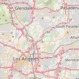
Los Angeles auf der Karte
Datenquellen & Methodik

Unsere Wettervorhersagen werden von einem professionellen Wetterdatenanbieter bereitgestellt, der Daten von nationalen Wetterdiensten, Satellitenbeobachtungen, Radarnetzwerken und über 80.000 Wetterstationen weltweit zusammenführt. Die Vorhersagedaten werden mehrmals täglich aktualisiert. Wir wandeln Rohdaten in übersichtliche Zusammenfassungen um – Windgeschwindigkeit in m/s, Luftdruck in mmHg – damit Sie Ihren Tag mit Zuversicht planen können.