
5-Tage-Wettervorhersage Niagara Falls 13. Okt. 2026
 20°
20°Wettervorhersage Niagara Falls heute 13. Okt. 2026: sonnig, Temperatur von 18 °C bis 25 °C.
Niederschlagswahrscheinlichkeit 54%. Wind bis zu 8.81 m/s (Böen 16.33 m/s). Luftfeuchtigkeit 54–86%, Luftdruck 755–758 mm Hg, UV-Index bis 4.4.
Wetterwarnungen
squall warning in effect
squall
Squalls with wind gusts up to 35 knots, frequent lightning and hail of 1 to 2 centimetres are expected or occurring in the area.
###
Please continue to monitor alerts and forecasts issued by Environment Canada. For more information monitor Canadian Coast Guard radio or Weatheradio stations.
5 Tage im Überblick — tippen Sie auf einen Tag, um ihn zu öffnen
Sonnenaufgang 07:27
Sonnenuntergang 18:37
Sonnenuntergang 18:37
Zunehmende Sichel11% beleuchtet
Mondaufgang 11:06 · Monduntergang 19:55
Mondaufgang 11:06 · Monduntergang 19:55
Diagramm
Tabelle
Di., 13. Okt. 2026
| Uhrzeit | Wetter | Temperatur | Regenwahrscheinlichkeit | Bewölkung | Feuchtigkeit | Druck | Wind | UV-Index |
|---|---|---|---|---|---|---|---|---|
| 00:00 | Klar | 19 °C | 8% | 3% | 76% | 758 mm Hg | SW 220° 5.39 (14.81) m/s | 0 |
| 01:00 | Klar | 19 °C | 8% | 5% | 78% | 758 mm Hg | SW 220° 5.39 (14.61) m/s | 0 |
| 02:00 |  Bedeckt | 19 °C | 22% | 100% | 78% | 758 mm Hg | SW 217° 5.19 (14.33) m/s | 0 |
| 03:00 |  Stellenweise Regen möglich | 19 °C | 26% (0.05 mm/Std.) | 98% | 78% | 757 mm Hg | SW 219° 5.19 (14.19) m/s | 0 |
| 04:00 |  Leichter Regenschauer | 18 °C | 36% (0.16 mm/Std.) | 96% | 81% | 757 mm Hg | SW 216° 5.11 (13.92) m/s | 0 |
| 05:00 | Stellenweise Regen möglich | 18 °C | 39% (0.14 mm/Std.) | 100% | 86% | 757 mm Hg | SW 222° 4.11 (13.81) m/s | 0 |
| 06:00 | Stellenweise Regen möglich | 18 °C | 38% (0.14 mm/Std.) | 100% | 83% | 757 mm Hg | SW 221° 4 (11.92) m/s | 0 |
| 07:00 | Leichter Regenschauer | 18 °C | 36% (0.18 mm/Std.) | 82% | 85% | 757 mm Hg | SW 214° 4.31 (12) m/s | 0 |
| 08:00 |  Bedeckt | 18 °C | 23% | 94% | 81% | 756 mm Hg | S 190° 4.19 (12.42) m/s | 0 |
| 09:00 |  Teilweise bewölkt | 19 °C | 12% | 56% | 74% | 756 mm Hg | S 190° 5.31 (14.03) m/s | 0.3 |
| 10:00 |  Stellenweise leichter Sprühregen | 21 °C | 29% (0.3 mm/Std.) | 73% | 66% | 756 mm Hg | SSW 212° 6.11 (15.22) m/s | 0.9 |
| 11:00 |  Leichter Sprühregen | 23 °C | 32% (0.27 mm/Std.) | 85% | 62% | 755 mm Hg | SW 221° 7.11 (15.22) m/s | 1.6 |
| 12:00 |  Vereinzelte Gewitter möglich | 24 °C | 17% (0.08 mm/Std.) | 83% | 58% | 755 mm Hg | SW 231° 8.39 (15.83) m/s | 3.5 |
| 13:00 |  Sonnig | 25 °C | 2% | 0% | 54% | 755 mm Hg | SW 232° 8.81 (15.81) m/s | 4.4 |
| 14:00 |  Zeitweise mäßiger Regen | 24 °C | 48% (0.96 mm/Std.) | 77% | 62% | 755 mm Hg | WSW 240° 8.19 (16.22) m/s | 4.3 |
| 15:00 |  Stellenweise leichter Regen mit Gewitter | 23 °C | 48% (0.93 mm/Std.) | 71% | 66% | 755 mm Hg | WSW 245° 7.69 (16.33) m/s | 3.3 |
| 16:00 | Zeitweise mäßiger Regen | 23 °C | 47% (0.71 mm/Std.) | 84% | 68% | 755 mm Hg | WSW 246° 7.31 (15.61) m/s | 2 |
| 17:00 | Zeitweise mäßiger Regen | 22 °C | 54% (0.91 mm/Std.) | 78% | 74% | 755 mm Hg | WSW 240° 6.19 (15.33) m/s | 0.9 |
| 18:00 | Sonnig | 21 °C | 8% | 0% | 76% | 755 mm Hg | SW 228° 5.5 (15.39) m/s | 0.2 |
| 19:00 | Klar | 20 °C | 9% | 0% | 79% | 755 mm Hg | SW 227° 5.19 (15.31) m/s | 0 |
| 20:00 | Klar | 20 °C | 9% | 0% | 80% | 755 mm Hg | WSW 238° 5.31 (14.81) m/s | 0 |
| 21:00 | Klar | 20 °C | 10% | 0% | 82% | 756 mm Hg | WSW 246° 4.39 (14.11) m/s | 0 |
| 22:00 | Klar | 20 °C | 9% | 0% | 80% | 757 mm Hg | W 273° 4.19 (11.61) m/s | 0 |
| 23:00 | Klar | 20 °C | 9% | 0% | 80% | 758 mm Hg | WNW 285° 4.81 (12.61) m/s | 0 |
Di., 13. Okt. 2026
Häufige Fragen zum 5-Tage-Wetter in Niagara Falls
Wie wird das Wetter in Niagara Falls in den nächsten 5 Tagen?
In den nächsten 5 Tagen liegt die Temperatur in Niagara Falls etwa zwischen 4 und 25 °C. Die detaillierte stündliche Vorhersage für jeden der 5 Tage finden Sie in den Diagrammen oben.
An welchen der nächsten 5 Tage regnet es in Niagara Falls?
Die Regenwahrscheinlichkeit in Niagara Falls erreicht in den nächsten 5 Tagen 90%. Im 5-Tage-Niederschlagsdiagramm oben sehen Sie, an welchen Tagen und Stunden es regnet.
Wie genau ist die 5-Tage-Wettervorhersage für Niagara Falls?
Eine 5-Tage-Vorhersage ist recht zuverlässig: Die ersten 2–3 Tage sind meist sehr genau, die Tage 4–5 können sich noch ändern. Die Daten werden mehrmals täglich aktualisiert – schauen Sie vor wichtigen Plänen noch einmal vorbei.
Welcher der nächsten 5 Tage in Niagara Falls wird am wärmsten und welcher am kühlsten?
In den nächsten 5 Tagen schwankt die Temperatur in Niagara Falls etwa zwischen 4 und 25 °C. Den wärmsten und den kühlsten Tag vergleichen Sie im Temperaturdiagramm oben.
Wird es in Niagara Falls in den nächsten 5 Tagen windig?
In den nächsten 5 Tagen frischt der Wind in Niagara Falls auf bis zu 9 m/s auf. Die windigsten Tage erkennen Sie im Winddiagramm oben.
Welcher Wochentag in Niagara Falls eignet sich am besten für einen Spaziergang oder einen Ausflug?
Für einen Spaziergang oder Ausflug wählen Sie die Tage mit der geringsten Regenwahrscheinlichkeit (bis zu 90%) und schwachem Wind – einfach in den 5-Tage-Diagrammen oben vergleichbar.
Wie nutze ich die 5-Tage-Vorhersage für Niagara Falls am besten?
Die ersten 2–3 Tage sind zuverlässig genug für feste Entscheidungen, während die Tage 4–5 als Orientierung dienen und mit Annäherung präziser werden. Die Vorhersage wird mehrmals täglich aktualisiert – prüfen Sie sie vor wichtigen Plänen noch einmal.
Brauche ich diese Woche in Niagara Falls einen Regenschirm oder Sonnencreme?
Die Regenwahrscheinlichkeit erreicht in den nächsten 5 Tagen 90%, nehmen Sie für die nassesten davon etwas Wasserfestes mit — welche das sind, zeigt die Tagesleiste oben. Der UV-Index erreicht heute 4.4; Sonnencreme lohnt sich etwa ab 3.
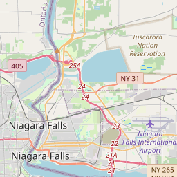
Niagara Falls auf der Karte
Datenquellen & Methodik
Unsere Wettervorhersagen werden von einem professionellen Wetterdatenanbieter bereitgestellt, der Daten von nationalen Wetterdiensten, Satellitenbeobachtungen, Radarnetzwerken und über 80.000 Wetterstationen weltweit zusammenführt. Die Vorhersagedaten werden mehrmals täglich aktualisiert. Wir wandeln Rohdaten in übersichtliche Zusammenfassungen um – Windgeschwindigkeit in m/s, Luftdruck in mmHg – damit Sie Ihren Tag mit Zuversicht planen können.