
5-Tage-Wettervorhersage Cold Lake 16. Nov. 2026
 6°
Wettervorhersage Cold Lake Montag 16. Nov. 2026: sonnig, Temperatur von 1 °C bis 6 °C.
Niederschlagswahrscheinlichkeit 16%. Wind bis zu 3.5 m/s (Böen 7.75 m/s). Luftfeuchtigkeit 60–85%, Luftdruck 754–759 mm Hg, UV-Index bis 0.6.
Wetterwarnungen
yellow advisory - fog - in effect
fog
Areas of dense fog are expected or occurring.
Conditions are expected to improve on Saturday.
###
Visibility will likely be suddenly reduced at times.
Please continue to monitor alerts and forecasts issued by Environment Canada. To report severe weather, send an email to ABstorm@ec.gc.ca, call 1-800-239-0484 or post reports on social media using #ABStorm.
Be prepared for areas of near-zero visibility and allow extra time to reach your destination. If driving, turn on your lights, slow down and maintain a safe following distance.
yellow advisory - fog - in effect
fog
Areas of dense fog are expected or occurring.
Conditions are expected to improve later today.
###
Visibility will likely be suddenly reduced at times.
Please continue to monitor alerts and forecasts issued by Environment Canada. To report severe weather, send an email to ABstorm@ec.gc.ca, call 1-800-239-0484 or post reports on social media using #ABStorm.
Be prepared for areas of near-zero visibility and allow extra time to reach your destination. If driving, turn on your lights, slow down and maintain a safe following distance.
5 Tage im Überblick — tippen Sie auf einen Tag, um ihn zu öffnen
Sonnenaufgang 08:52
Sonnenuntergang 17:18
Sonnenuntergang 17:18
Erstes Viertel52% beleuchtet
Mondaufgang 14:40 · Monduntergang geht heute nicht unter
Mondaufgang 14:40 · Monduntergang geht heute nicht unter
Diagramm
Tabelle
| Uhrzeit | Wetter | Temperatur | Regenwahrscheinlichkeit | Bewölkung | Feuchtigkeit | Druck | Wind | UV-Index |
|---|---|---|---|---|---|---|---|---|
| 00:00 |  Teilweise bewölkt | 1 °C | 11% | 26% | 79% | 754 mm Hg | SW 234° 2.89 (5.39) m/s | 0 |
| 01:00 | Teilweise bewölkt | 1 °C | 13% | 37% | 79% | 755 mm Hg | SW 235° 3 (5.36) m/s | 0 |
| 02:00 | Teilweise bewölkt | 1 °C | 14% | 47% | 79% | 755 mm Hg | SW 234° 3.19 (6.75) m/s | 0 |
| 03:00 | Teilweise bewölkt | 1 °C | 16% | 58% | 79% | 755 mm Hg | WSW 240° 3.5 (7.75) m/s | 0 |
| 04:00 | Teilweise bewölkt | 1 °C | 13% | 39% | 80% | 755 mm Hg | WSW 245° 3.39 (7.31) m/s | 0 |
| 05:00 |  Klar | 1 °C | 12% | 20% | 82% | 756 mm Hg | WSW 250° 3.19 (7.08) m/s | 0 |
| 06:00 | Klar | 0 °C | 11% | 0% | 84% | 756 mm Hg | WSW 247° 3 (5.5) m/s | 0 |
| 07:00 | Klar | 0 °C | 12% | 6% | 85% | 756 mm Hg | WSW 253° 2.69 (4.33) m/s | 0 |
| 08:00 | Sonnig | 0 °C | 12% | 13% | 85% | 757 mm Hg | WSW 252° 2.69 (4.5) m/s | 0 |
| 09:00 | Sonnig | 0 °C | 13% | 21% | 85% | 757 mm Hg | WSW 251° 2.39 (3.61) m/s | 0 |
| 10:00 |  Teilweise bewölkt | 1 °C | 14% | 37% | 81% | 757 mm Hg | WSW 252° 2.5 (5.14) m/s | 0.3 |
| 11:00 | Sonnig | 2 °C | 9% | 19% | 75% | 757 mm Hg | WSW 246° 2.39 (5.28) m/s | 0.5 |
| 12:00 | Sonnig | 4 °C | 7% | 18% | 69% | 757 mm Hg | WSW 246° 2.39 (4.81) m/s | 0.6 |
| 13:00 | Teilweise bewölkt | 5 °C | 7% | 28% | 65% | 757 mm Hg | WSW 244° 2.39 (4.61) m/s | 0.5 |
| 14:00 | Teilweise bewölkt | 6 °C | 7% | 39% | 62% | 757 mm Hg | WSW 237° 2.61 (4.69) m/s | 0.4 |
| 15:00 | Teilweise bewölkt | 6 °C | 7% | 48% | 60% | 757 mm Hg | SW 230° 2.89 (5.17) m/s | 0.2 |
| 16:00 | Teilweise bewölkt | 5 °C | 7% | 33% | 64% | 757 mm Hg | SW 235° 2.89 (5.44) m/s | 0 |
| 17:00 | Klar | 3 °C | 7% | 19% | 69% | 757 mm Hg | WSW 240° 2.89 (5.28) m/s | 0 |
| 18:00 | Klar | 2 °C | 7% | 6% | 72% | 758 mm Hg | WSW 242° 3.11 (4.92) m/s | 0 |
| 19:00 | Klar | 2 °C | 8% | 4% | 74% | 758 mm Hg | WSW 245° 3.19 (5.08) m/s | 0 |
| 20:00 | Klar | 1 °C | 8% | 2% | 75% | 758 mm Hg | WSW 250° 3.39 (6.19) m/s | 0 |
| 21:00 | Klar | 1 °C | 8% | 0% | 75% | 758 mm Hg | WSW 249° 3.39 (5.89) m/s | 0 |
| 22:00 | Klar | 1 °C | 7% | 0% | 73% | 759 mm Hg | WSW 246° 3.39 (5.39) m/s | 0 |
| 23:00 | Klar | 1 °C | 6% | 1% | 71% | 759 mm Hg | WSW 246° 3.39 (5.06) m/s | 0 |
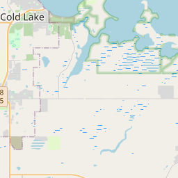
Cold Lake auf der Karte
Datenquellen & Methodik
Unsere Wettervorhersagen werden von einem professionellen Wetterdatenanbieter bereitgestellt, der Daten von nationalen Wetterdiensten, Satellitenbeobachtungen, Radarnetzwerken und über 80.000 Wetterstationen weltweit zusammenführt. Die Vorhersagedaten werden mehrmals täglich aktualisiert. Wir wandeln Rohdaten in übersichtliche Zusammenfassungen um – Windgeschwindigkeit in m/s, Luftdruck in mmHg – damit Sie Ihren Tag mit Zuversicht planen können.