
5-Tage-Wettervorhersage Auerbach 25. Okt. 2026
 8°
8°Wettervorhersage Auerbach Sonntag 25. Okt. 2026: bedeckt, Temperatur von 1 °C bis 8 °C.
Niederschlagswahrscheinlichkeit 85%. Wind bis zu 8.69 m/s (Böen 18.42 m/s). Luftfeuchtigkeit 60–95%, Luftdruck 755–766 mm Hg, UV-Index bis 2.
Wetterwarnungen
Moderate Wind Related Impact
SE wind with gusts between 15 and 20 m/s (55 to 70 km/h).
Possible complications in the energy industry, forestry, and transport. Possible damage to trees and forests. Minor damage to energy infrastructure, property (especially older buildings). Risk of injury from flying or falling objects, especially broken branches. Minor travel delays due to debris and outages.
Secure windows, doors, remove or anchor loosely stored objects, tents, greenhouses, etc. Watch out for falling objects such as branches or roof tiles. When driving, watch out for strong crosswinds at exposed points such as bridges, drive slowly. In the mountains, limit hikes and avoid ridge areas in particular.
Moderate Wind Related Impact
SE wind with gusts between 15 and 20 m/s (55 to 70 km/h).
Possible complications in the energy industry, forestry, and transport. Possible damage to trees and forests. Minor damage to energy infrastructure, property (especially older buildings). Risk of injury from flying or falling objects, especially broken branches. Minor travel delays due to debris and outages.
Secure windows, doors, remove or anchor loosely stored objects, tents, greenhouses, etc. Watch out for falling objects such as branches or roof tiles. When driving, watch out for strong crosswinds at exposed points such as bridges, drive slowly. In the mountains, limit hikes and avoid ridge areas in particular.
Moderate Wind Related Impact
SE wind with gusts between 15 and 20 m/s (55 to 70 km/h).
Possible complications in the energy industry, forestry, and transport. Possible damage to trees and forests. Minor damage to energy infrastructure, property (especially older buildings). Risk of injury from flying or falling objects, especially broken branches. Minor travel delays due to debris and outages.
Secure windows, doors, remove or anchor loosely stored objects, tents, greenhouses, etc. Watch out for falling objects such as branches or roof tiles. When driving, watch out for strong crosswinds at exposed points such as bridges, drive slowly. In the mountains, limit hikes and avoid ridge areas in particular.
Moderate Wind Related Impact
SE wind with gusts between 15 and 20 m/s (55 to 70 km/h).
Possible complications in the energy industry, forestry, and transport. Possible damage to trees and forests. Minor damage to energy infrastructure, property (especially older buildings). Risk of injury from flying or falling objects, especially broken branches. Minor travel delays due to debris and outages.
Secure windows, doors, remove or anchor loosely stored objects, tents, greenhouses, etc. Watch out for falling objects such as branches or roof tiles. When driving, watch out for strong crosswinds at exposed points such as bridges, drive slowly. In the mountains, limit hikes and avoid ridge areas in particular.
5 Tage im Überblick — tippen Sie auf einen Tag, um ihn zu öffnen
Sonnenaufgang 06:49
Sonnenuntergang 16:59
Sonnenuntergang 16:59
Vollmond100% beleuchtet
Mondaufgang 16:12 · Monduntergang 05:56
Mondaufgang 16:12 · Monduntergang 05:56
Diagramm
Tabelle
So., 25. Okt. 2026
| Uhrzeit | Wetter | Temperatur | Regenwahrscheinlichkeit | Bewölkung | Feuchtigkeit | Druck | Wind | UV-Index |
|---|---|---|---|---|---|---|---|---|
| 00:00 |  Teilweise bewölkt | 4 °C | 18% | 51% | 87% | 766 mm Hg | SW 218° 4.5 (10.92) m/s | 0 |
| 01:00 | Teilweise bewölkt | 4 °C | 17% | 50% | 86% | 766 mm Hg | SW 219° 4.19 (10.72) m/s | 0 |
| 02:00 |  Klar | 3 °C | 14% | 10% | 90% | 766 mm Hg | SSW 200° 3.61 (10.61) m/s | 0 |
| 03:00 | Klar | 2 °C | 15% | 7% | 93% | 765 mm Hg | S 191° 3.5 (10.81) m/s | 0 |
| 04:00 | Klar | 2 °C | 15% | 4% | 92% | 765 mm Hg | S 187° 3.61 (11.22) m/s | 0 |
| 05:00 | Klar | 2 °C | 15% | 6% | 92% | 765 mm Hg | S 183° 3.61 (11.61) m/s | 0 |
| 06:00 | Klar | 1 °C | 16% | 16% | 92% | 764 mm Hg | S 180° 3.69 (11.92) m/s | 0 |
| 07:00 |  Bewölkt | 1 °C | 27% | 82% | 93% | 764 mm Hg | S 173° 3.69 (12.42) m/s | 0 |
| 08:00 | Bedeckt | 2 °C | 29% | 100% | 88% | 764 mm Hg | S 179° 4.11 (12.92) m/s | 1 |
| 09:00 | Bedeckt | 4 °C | 22% | 100% | 76% | 763 mm Hg | S 180° 4.89 (13.11) m/s | 1 |
| 10:00 | Bedeckt | 5 °C | 17% | 89% | 70% | 761 mm Hg | S 182° 5.5 (13.89) m/s | 2 |
| 11:00 | Bedeckt | 7 °C | 16% | 100% | 64% | 760 mm Hg | S 184° 6.81 (14.72) m/s | 2 |
| 12:00 | Bedeckt | 7 °C | 16% | 100% | 62% | 759 mm Hg | S 184° 7 (15.31) m/s | 2 |
| 13:00 | Bedeckt | 8 °C | 14% | 98% | 60% | 758 mm Hg | S 183° 7.61 (15.92) m/s | 2 |
| 14:00 |  Leichter Regen | 7 °C | 40% (0.4 mm/Std.) | 99% | 65% | 757 mm Hg | S 184° 8 (16.69) m/s | 2 |
| 15:00 | Bedeckt | 7 °C | 54% (0.7 mm/Std.) | 99% | 71% | 756 mm Hg | S 185° 8.31 (17.61) m/s | 2 |
| 16:00 | Leichter Regen | 6 °C | 67% (1.12 mm/Std.) | 100% | 77% | 755 mm Hg | S 185° 8.69 (18.42) m/s | 2 |
| 17:00 |  Mäßiger Regen | 6 °C | 73% (1.6 mm/Std.) | 100% | 82% | 755 mm Hg | S 190° 8.5 (18.19) m/s | 2 |
| 18:00 |  Leichter Regen | 6 °C | 79% (2.1 mm/Std.) | 100% | 87% | 755 mm Hg | SSW 194° 8.19 (17.89) m/s | 0 |
| 19:00 |  Mäßiger Regen | 6 °C | 85% (2.65 mm/Std.) | 100% | 92% | 755 mm Hg | SSW 199° 8 (17.72) m/s | 0 |
| 20:00 |  Leichter Sprühregen | 6 °C | 82% (1.9 mm/Std.) | 100% | 93% | 755 mm Hg | SW 227° 7.5 (15.69) m/s | 0 |
| 21:00 | Mäßiger Regen | 7 °C | 80% (1.2 mm/Std.) | 100% | 94% | 756 mm Hg | WSW 255° 7.11 (13.81) m/s | 0 |
| 22:00 | Leichter Sprühregen | 7 °C | 69% (0.48 mm/Std.) | 100% | 95% | 757 mm Hg | WNW 283° 6.61 (11.81) m/s | 0 |
| 23:00 |  Leichter Regenschauer | 7 °C | 59% (0.4 mm/Std.) | 91% | 93% | 758 mm Hg | W 281° 6.31 (12) m/s | 0 |
So., 25. Okt. 2026
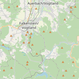
Auerbach auf der Karte
Datenquellen & Methodik
Unsere Wettervorhersagen werden von einem professionellen Wetterdatenanbieter bereitgestellt, der Daten von nationalen Wetterdiensten, Satellitenbeobachtungen, Radarnetzwerken und über 80.000 Wetterstationen weltweit zusammenführt. Die Vorhersagedaten werden mehrmals täglich aktualisiert. Wir wandeln Rohdaten in übersichtliche Zusammenfassungen um – Windgeschwindigkeit in m/s, Luftdruck in mmHg – damit Sie Ihren Tag mit Zuversicht planen können.